<Back to Index>
- Explorer David Thompson, 1770
- Painter and Composer Luigi Russolo, 1883
- King of Poland Kazimierz III Wielki, 1310
PAGE SPONSOR
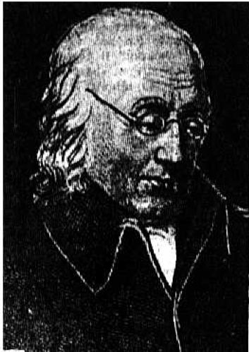

David Thompson (April 30, 1770 – February 10, 1857) was an English - Canadian fur trader, surveyor, and map maker, known to some native peoples as "Koo-Koo-Sint" or "the Stargazer". Over his career he mapped over 3.9 million square kilometers of North America and for this has been described as the "greatest land geographer who ever lived."
Thompson was born in Westminster to recent Welsh migrants, David and Ann Thompson. When Thompson was two, his father died and the financial hardship of this occurrence resulted in his and his brother's placement in the Grey Coat Hospital, a school for the disadvantaged of Westminster. He eventually graduated to the Grey Coat mathematical school and was introduced to basic navigation skills which would form the basis of his future career. In 1784, at the age of 14, he entered a seven year apprenticeship with the Hudson's Bay Company. He set sail on May 28 of that year, and left England forever.
He arrived in Churchill (now in Manitoba) and was put to work copying the personal papers of the governor of Fort Churchill, Samuel Hearne. The next year he was transferred to nearby York Factory, and over the next few years spent time as a clerk at Cumberland House and South Branch House before arriving at Manchester House in 1787. On December 23, 1788, Thompson seriously fractured his leg, forcing him to spend the next two winters at Cumberland House convalescing. It was during this time he greatly refined and expanded his mathematical, astronomical and surveying skills under the tutelage of Hudson's Bay Company surveyor Philip Turnor. It was also during this time that he lost sight in his right eye.
In
1790 with his apprenticeship nearing its end, Thompson made the unusual
request of a set of surveying tools in place of the typical parting
gift of fine clothes offered by the company to those completing their
indenture. He received both. He then entered the employ of the Hudson's
Bay Company as a fur trader and in 1792 completed his first significant
survey, mapping a route to Lake Athabasca (presently straddling the Alberta / Saskatchewan border).
In recognition of his map making skills, the company promoted him to
surveyor in 1794. Thompson continued working for the Hudson's Bay
Company until May 23, 1797 when, frustrated with the Hudson's Bay
Company's policies, he left and walked 80 miles in the snow to enter
the employ of the competition, the North West Company where he continued to work as a fur trader and surveyor.
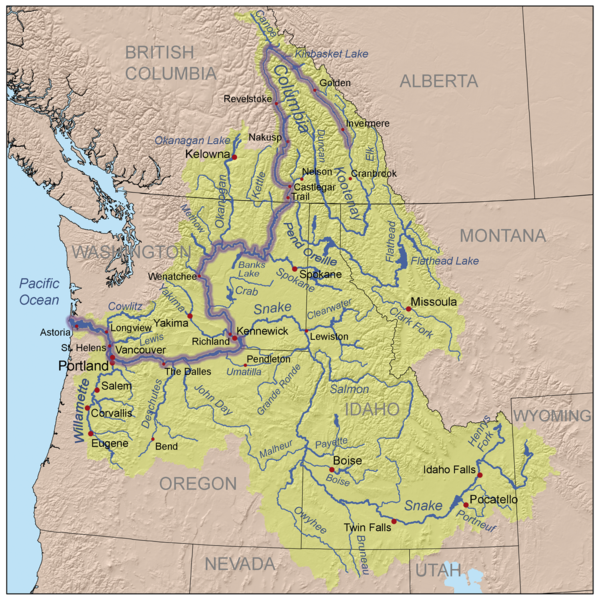
Thompson's decision to defect to the North West Company in 1797 without providing the customary one year notice was not well received by his former employers. However, joining the North West Company allowed Thompson to pursue his interest in surveying and work on mapping the interior of what was to become Canada. In 1797, Thompson was sent south by his employers to survey part of Canada - U.S. boundary along the water routes from Lake Superior to Lake of the Woods to satisfy unresolved questions of territory arising from the Jay Treaty between Great Britain and the United States. By 1798 Thompson had completed a survey of 6,750 km (4,190 mi) from Grand Portage, through Lake Winnipeg, to the headwaters of the Assiniboine and Mississippi Rivers, as well as two sides of Lake Superior. In 1798, the company sent him to Red Deer Lake (in present day Alberta) to establish a trading post. Thompson spent the next few seasons trading based in Fort George (now in Alberta), and during this time led several expeditions into the Rocky Mountains.
In 1804, at the annual meeting of the North West Company in Kaministiquia, Thompson was made a full partner of the company and spent the next few seasons based there managing the fur trading operations but still finding time to expand his surveys of the waterways around Lake Superior. However, a decision was made at the 1806 company meeting to send Thompson back out into the interior. Concern over the American backed expedition of Lewis and Clark prompted the North West Company to charge Thompson with the task of finding a route to the Pacific in order to open up the lucrative trading territories of the Pacific Northwest.
After the general meeting in 1806, Thompson travelled to Rocky Mountain House and prepared for an expedition to follow the Columbia River to
the Pacific. In June 1807 Thompson crossed the Rocky Mountains and
spent the summer surveying the Columbia basin and continuing to survey
the area over the next few seasons. Thompson mapped and established
trading posts in Northwestern Montana, Idaho, Washington, and Western Canada; including Kootenae House and Saleesh House;
the first trading post west of the Rockies in Montana extending North
West Company fur trading territories. The maps he made of the Columbia
River basin east of the Cascade Mountains were
of such high quality and detail that they continued to be regarded as
authoritative well into the mid 20th century. in fact, Thompson’s
drawings of the upper portion of the Missouri River were incorporated
into a map for the Lewis and Clark expedition that followed seven years
later.
In early 1810, Thompson was returning eastward towards Montreal but while on route at Rainy Lake, received orders to return to the Rocky Mountains and establish a route to the mouth of the Columbia. This was a response by the North West Company to the plans of John Jacob Astor to send a ship around the Americas to establish a fur trading post. During his return, Thompson was delayed by an angry group of Peigan natives which ultimately forced him to seek a new route across the Rocky Mountains through the Athabasca Pass.
David Thompson was the first European to navigate the full length of the Columbia River. During Thompson's 1811 voyage down the Columbia River he camped at the junction with the Snake River on July 9, 1811, and erected a pole and a notice claiming the country for Great Britain and stating the intention of the North West Company to build a trading post at the site. This notice was found later that year by Astorians looking to establish an inland fur post, contributing to their selection of a more northerly site at Fort Okanogan. The North West Company's Fort Nez Percés was established near the Snake River junction several years later. Continuing down the Columbia, Thompson passed the barrier of The Dalles with much less difficulty than experienced by Lewis and Clark, as high water obscured Celilo Falls and many of the rapids. On July 14, 1811, Thompson reached the partially constructed Fort Astoria at the mouth of the Columbia, arriving two months after the Pacific Fur Company's ship, the Tonquin.
Before returning upriver and across the mountains, Thompson hired Naukane, a Native Hawaiian laborer brought to Fort Astoria by the Pacific Fur Company's ship Tonquin. Naukane, known as Coxe to Thompson, accompanied Thompson across the continent to Lake Superior before journeying on to England.
Thompson wintered at Saleesh House before beginning his final journey back to Montreal in 1812.
In his published journals, Thompson recorded seeing large footprints near what is now Jasper, Alberta, in 1811. It has been suggested that these prints were similar to what has since been called the sasquatch. However, Thompson noted that these tracks showed "a small Nail at the end of each [toe]", and stated that these tracks "very much resembles a large Bear's Track".
He married
Charlotte Small on June 10, 1799 at Île - à - la - Crosse, a mixed blood child of a Scottish fur trader and a Cree mother. Their marriage was formalized at the Scotch Presbyterian Church in Montreal on
October 30, 1812. He and Charlotte had 13 children together; five of
them were born before he left the fur trade. The family did not adjust
easily to life in Eastern Canada and two of the children, John (aged 5)
and Emma (aged 7) died of round worms, a common parasite. Their marriage lasted 58 years, the longest Canadian pre-Confederation marriage known.
In 1815, Thompson moved his family to Williamstown, Upper Canada, and a few years later was employed to survey the newly established borders with the United States from Lake of the Woods to the Eastern Townships of Quebec, established by Treaty of Ghent after the War of 1812. In 1843 Thompson completed his atlas of the region from Hudson Bay to the Pacific Ocean.
Afterwards,
Thompson returned to a life as a land owner, but soon financial
misfortune would ruin him. By 1831 he was so deeply in debt he was
forced to take up a position as a surveyor for the British American
Land Company to provide for his family. His luck continued to worsen
and he was forced to move in with this daughter and son - in - law in 1845.
He began work on a manuscript chronicling his life exploring the
continent, but this project was left unfinished when his sight failed
him completely in 1851.
The land mass mapped by Thompson amounted to 3.9 million square kilometres of wilderness (one - fifth of the continent). His contemporary, the great explorer Alexander Mackenzie, remarked that Thompson did more in ten months than he would have thought possible in two years.
Despite these significant achievements, Thompson died in Montreal in near obscurity on February 10, 1857, his accomplishments almost unrecognized. He never finished the book of his 28 years in the fur trade, based on his 77 field notebooks, before he died. In the 1890s geologist J.B. Tyrrell resurrected Thompson's notes and in 1916 published them as David Thompson's Narrative.
Thompson's body was interred in Montreal's Mount Royal Cemetery in an unmarked grave. It was not until 1926 that efforts by J.B. Tyrell and the Canadian Historical Society resulted in the placing of a tombstone to mark his grave.
In 1957, one hundred years after his death, the Canadian government honoured him with his image on a Canadian postage stamp. The David Thompson Highway in Alberta was named in his honour, along with David Thompson High School situated on the side of the highway near Leslieville, Alberta.
His prowess as a geographer is now well recognized. He has been called
"the greatest land geographer who ever lived." There is a monument
dedicated to David Thompson (maintained by the state of
North Dakota) near the former town site of the ghost town, Verendrye, North Dakota, located approximately two miles north and one mile west of Karlsruhe, North Dakota. Thompson Falls, Montana, and British Columbia's Thompson River are
also named after the explorer. The
year 2007 marked the 150th year of Thompson's death and the 200th
anniversary of his first crossing of the Rocky Mountains. Commemorative
events and exhibits are planned across Canada and the United States
from 2007 to 2011 as a celebration of his accomplishments. Thompson was the subject of a 1964 National Film Board of Canada short film David Thompson: The Great Mapmaker, as well as the BBC2 programme Ray Mears' Northern Wilderness (Episode 5), broadcast in November 2009.