<Back to Index>
- No. 4 Asia Aral Sea, 68K
PAGE SPONSOR
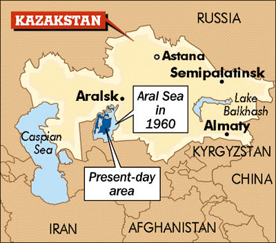
The Aral Sea (Kazakh: Арал Теңізі Aral Teñizi; Uzbek: Orol Dengizi; Russian: Аральскοе Мοре Aral'skoye More; Tajik: Баҳри Арал Bahri Aral; Persian: دریاچه خوارزم Daryâche-ye Khârazm) was a lake that lay between Kazakhstan (Aktobe and Kyzylorda provinces) in the north and Karakalpakstan, an autonomous region of Uzbekistan, in the south. The name roughly translates as "Sea of Islands", referring to more than 1,534 islands that once dotted its waters.
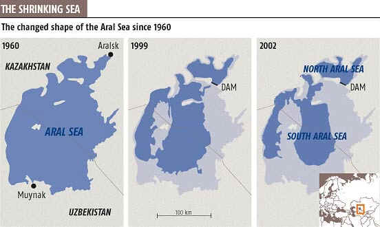
Formerly one of the four largest lakes in the world with an area of 68,000 square kilometres (26,300 sq mi), the Aral Sea has been steadily shrinking since the 1960s after the rivers that fed it were diverted by Soviet Union irrigation projects. By 2007 it had declined to 10% of its original size, splitting into four lakes – the North Aral Sea and the eastern and western basins of the once far larger South Aral Sea and one smaller lake between North and South Aral Sea. By 2009, the south - eastern lake had disappeared and the south - western lake retreated to a thin strip at the extreme west of the former southern sea. The maximum depth of the North Aral Sea is 42 m (138 ft) (as of 2008).
The region's once prosperous fishing industry has been essentially destroyed, bringing unemployment and economic hardship. The Aral Sea region is also heavily polluted, with consequent serious public health problems. The retreat of the sea has reportedly also caused local climate change, with summers becoming hotter and drier, and winters colder and longer.
There
is now an ongoing effort in Kazakhstan to save and replenish the North
Aral Sea. As part of this effort, a dam project was completed in 2005;
in 2008, the water level in this lake had risen by 24 m
(79 ft) from its lowest level in 2007. Salinity
has dropped, and fish are again found in sufficient numbers for some
fishing to be viable. However, the outlook for the remnants of the South
Aral Sea remains bleak. The shrinking of the Aral Sea has been called
"one of the planet's worst environmental disasters".
Russian military presence on the Sea of Aral started in 1847, with the founding of Raimsk, which was soon renamed Aralsk, near the mouth of the Syr Darya. Soon, the Imperial Russian Navy started deploying its vessels on the sea. Owing to the Aral Sea basin not being connected to other bodies of water, the vessels had to be disassembled in Orenburg on the Ural River, shipped overland to Aralsk (presumably by a camel caravan), and then re-assembled. The first two ships, assembled in 1847, were the two - masted schooners named Nikolai and Mikhail. The former was a warship, the latter a merchant vessel meant to serve for the establishment of the fisheries on the great lake. In 1848, these two vessels surveyed the northern part of the sea. In the same year, a larger warship, the Constantine, was assembled as well. Commanded by Lt. Alexey Butakov (Алексей Бутаков), the Constantine completed the survey of the entire Aral Sea over the next two years. The exiled Ukrainian poet and painter Taras Shevchenko participated in the expedition, and painted a number of sketches of the Aral Sea coast.
For
the navigation of 1851, two newly built steamers arrived from Sweden,
again via caravan from Orenburg. As the geological surveys had found no
coal deposits in the area, the Military Governor - General of Orenburg Vasily Perovsky ordered "as large as possible supply" of saxaul (a desert shrub, akin to the creosote bush) to be collected in Aralsk for use by the new steamers. Unfortunately, saxaul wood did not turn out a very suitable fuel, and in the later years the Aral Flotilla was provisioned, at substantial cost, by Donets coal.
In the early 1960s, the Soviet government decided that the two rivers that fed the Aral Sea, the Amu Darya in the south and the Syr Darya in the northeast, would be diverted to irrigate the desert, in order to attempt to grow rice, melons, cereals, and cotton. This was part of the Soviet plan for cotton, or "white gold", to become a major export. This eventually succeeded, and today Uzbekistan is one of the world's largest exporters of cotton.
The construction of irrigation canals began on a large scale in the 1940s. Many of the canals were poorly built, allowing water to leak or evaporate. From the Qaraqum Canal, the largest in Central Asia, perhaps 30 to 75% of the water went to waste. Today only 12% of Uzbekistan's irrigation canal length is waterproofed.
There are 47, 750 km of inter - farm irrigation channels in the basin, of which only 28% have anti - filtration linings. Only 77% of farm intakes have flow gauges, and of the 268, 500 km of on - farm channels, only 21% have anti - infiltration linings, which retain on average 15% more water then unlined channels.
By 1960, between 20 and 60 cubic kilometres (4.8 and 14 cu mi) of water were going each year to the land instead of the sea. Most of the sea's water supply had been diverted, and in the 1960s the Aral Sea began to shrink. From 1961 to 1970, the Aral's sea level fell at an average of 20 cm (7.9 in) a year; in the 1970s, the average rate nearly tripled to 50 – 60 centimetres (20 – 24 in) per year, and by the 1980s it continued to drop, now with a mean of 80 – 90 centimetres (31 – 35 in) each year. The rate of water usage for irrigation continued to increase: the amount of water taken from the rivers doubled between 1960 and 2000, and cotton production nearly doubled in the same period.
The disappearance of the lake was no surprise to the Soviets; they expected it to happen long before. As early as in 1964, Aleksandr Asarin at the Hydroproject Institute pointed out that the lake was doomed, explaining "It was part of the five year plans, approved by the council of ministers and the Politburo. Nobody on a lower level would dare to say a word contradicting those plans, even if it was the fate of the Aral Sea."
The reaction to the predictions varied. Some Soviet experts apparently considered the Aral to be "nature's error", and a Soviet engineer said in 1968 that "it is obvious to everyone that the evaporation of the Aral Sea is inevitable." On the other hand, starting in the 1960s, a large scale project was proposed to redirect part of the flow of the rivers of the Ob basin to Central Asia over a gigantic canal system. Refilling of the Aral Sea was considered as one of the project's main goals. However, due to its staggering costs and the negative public opinion in Russia proper, the federal authorities abandoned the project by 1986.
From
1960 to 1998, the sea's surface area shrank by approximately 60%, and
its volume by 80%. In 1960, the Aral Sea had been the world's
fourth - largest lake, with an area of approximately 68,000 square
kilometres (26,000 sq mi) and a volume of 1,100 cubic kilometres
(260 cu mi); by 1998, it had dropped to 28,687 square
kilometres (11,076 sq mi), and eighth largest. The amount of
water it has lost is the equivalent of completely draining Lake Erie and Lake Ontario. Over the same time period its salinity increased from about 10 g/L to about 45 g/L.
In 1987, the continuing shrinkage split the lake into two separate bodies of water, the North Aral Sea (the Lesser Sea, or Small Aral Sea) and the South Aral Sea (the Greater Sea, or Large Aral Sea).
In 1991 Uzbekistan gained independence from the Soviet Union. Craig Murray, a UK ambassador to Uzbekistan in 2002, described the independence as a way for Islam Karimov to consolidate his power rather than a move away from a Soviet style economy and philosophy towards exploitation of the land. Murray attributes the shrinkage of the Aral Sea in the 1990s to Karimov's cotton policy. The government maintained a massive irrigation system which Murray described as massively wasteful with most of the water being lost through evaporation before reaching the cotton. Crop rotation was not used and the depleted soil and monoculture required massive quantities of pesticides and fertilizer. The runoff from the fields washed these chemicals into the shrinking Sea, creating severe pollution and health problems. Murray compared the system to the slavery system in the pre - civil war United States; forced labor was used and profits were siphoned off by the powerful and well connected. Murray contrasts this to Kazakhstan, in which the cotton industry had been privatized.
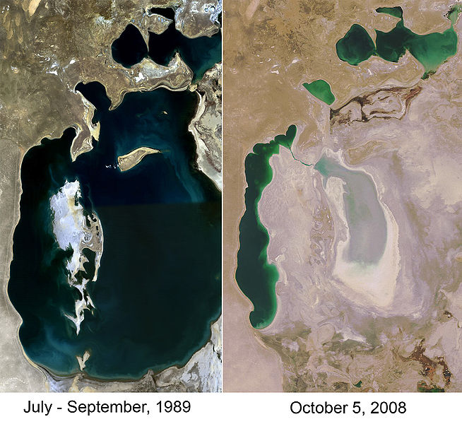
By summer 2003, the South Aral Sea was vanishing faster than predicted. In the deepest parts of the sea, the bottom waters were saltier than the top, and not mixing. Thus, only the top of the sea was heated in the summer, and it evaporated faster than would otherwise be expected. In 2003, the South Aral further divided into eastern and western basins.
In 2004, the Aral Sea's surface area was only 17,160 km2 (6,630 sq mi), 25% of its original size, and a nearly fivefold increase in salinity had killed most of its natural flora and fauna. By 2007 the sea's area had further shrunk to 10% of its original size, and the salinity of the remains of the South Aral had increased to levels in excess of 100 g/L. (By comparison, the salinity of ordinary seawater is typically around 35 g/L; the Dead Sea's salinity varies between 300 and 350 g/L.) The decline of the North Aral has now been partially reversed following construction of a dam but the remnants of the South Aral continue to disappear and its drastic shrinkage has created the Aralkum, a desert on the former lake bed.
There is an inflow of groundwater discharge into the South Aral Sea, but it will not in itself be able to stop the desiccation. This
inflow of about 4 cubic kilometres (0.96 cu mi) per year is
larger than previously estimated. This groundwater originates in the Pamirs and Tian Shan mountains and finds its way through geological layers to a fracture zone at the bottom of the Aral.
The ecosystem of the Aral Sea and the river deltas feeding into it has been nearly destroyed, not least because of the much higher salinity. The receding sea has left huge plains covered with salt and toxic chemicals – the results of weapons testing, industrial projects, pesticides and fertilizer runoff – which are picked up and carried away by the wind as toxic dust and spread to the surrounding area. The land around the Aral Sea is heavily polluted and the people living in the area are suffering from a lack of fresh water and health problems, including high rates of certain forms of cancer and lung diseases. Respiratory illnesses including tuberculosis (most of which is drug resistant) and cancer, digestive disorders, anaemia, and infectious diseases are common ailments in the region. Liver, kidney and eye problems can also be attributed to the toxic dust storms. Health concerns associated with the region are a cause for an unusually high fatality rate amongst vulnerable parts of the population. There is a high child mortality rate of 75 in every 1,000 newborns and maternity death of 12 in every 1,000 women. Crops in the region are destroyed by salt being deposited onto the land. Vast salt plains exposed by the shrinking Aral have produced dust storms, making regional winters colder and summers hotter.
The Aral Sea fishing industry, which in its heyday had employed some 40,000 and reportedly produced one - sixth of the Soviet Union's entire fish catch, has been devastated, and former fishing towns along the original shores have become ship graveyards. The town of Moynaq in Uzbekistan had a thriving harbor and fishing industry that employed approximately 30,000 people; now it lies miles from the shore. Fishing boats lie scattered on the dry land that was once covered by water; many have been there for 20 years. The only significant fishing company left in the area has its fish shipped from the Baltic Sea, thousands of kilometers away.
Also destroyed is the muskrat trapping industry in the deltas of Amu Darya and Syr Darya, which used to yield as much as 500,000 muskrat pelts a year.
The overall cost of the damage to the region has been estimated at 35 - 40 billion roubles (£800 million).
Many different solutions to the different problems have been suggested over the years, varying in feasibility and cost, including the following:
- Improving the quality of irrigation canals;
- Installing desalination plants;
- Charging farmers to use the water from the rivers;
- Using alternative cotton varieties that require less water;
- Using fewer chemicals on the cotton;
- Moving farming away from cotton;
- Installing dams to fill the Aral Sea;
- Redirecting water from the Volga, Ob and Irtysh rivers. This would restore the Aral Sea to its former size in 20 – 30 years at a cost of US$ 30 – 50 billion;
- Pumping sea water into the Aral Sea from the Caspian Sea via a pipeline, and diluting with freshwater from local catchment areas.
In January 1994, the countries of Kazakhstan, Uzbekistan, Turkmenistan, Tajikistan and Kyrgyzstan signed a deal to pledge 1% of their budgets to helping the sea recover.
In March 2000 UNESCO presented their Water - related vision for the Aral Sea basin for the year 2025 at the second World Water Forum in The Hague. This document was criticized for setting unrealistic goals, and also for giving insufficient attention to the interests of the area immediately around the former lakesite, implicitly giving up on the Aral Sea and the people living on the Uzbek side of the lake.
By
2006, the World Bank's restoration projects, especially in the North
Aral, were giving rise to some unexpected, tentative relief in what had
been an extremely pessimistic picture.
An Islamabad based think tank, SDPI (Sustainable Development Policy Institute) has established a working group on saving the Aral Sea which will focus only on transboundary water management and the environmental, economic and energy issues of Central Asia. Based in Pakistan, SDPI performs research on sustainable development issues and provides information for concerned individuals and institutions. The mandate of the working group is to evaluate the shrinking of the Aral Sea , a phenomenon to have simultaneous impacts on the region’s economic and environmental stability. The ecological consequences of the shrinking Aral Sea will not respect any political boundaries and are bound to adversely affect the region.
Invoking the issue of Aral Sea is an endeavor to highlight the need for equitable distribution of water resources based on international laws and best practices.
Additionally, the urgent need to rehabilitate / refill the Aral Sea is crucial for the stabilization of the regional and global climate in addition to maintaining peace and security in Central Asia.
The
need for a working group on the subject was also reinforced after the
devastating flood in Pakistan when a westerly weather system collided
with the monsoon weather system during the last week of July 2010
causing unprecedented flash floods in Pakistan. The technical part of
the Working Group will make assessments of the state of environment in
Central Asia and plausible impacts on climate of Pakistan and the region as a
whole.
The future of the Aral Sea, and the responsibility for its survival are now in the hands of the five countries; Kazakhstan, Uzbekistan, Tajikistan, Kyrgyzstan and Turkmenistan. In 1994 they adopted the ASBP (Aral Sea Basin Program). The Program’s four objectives are:
- To stabilize the environment of the Aral Sea Basin;
- To rehabilitate the disaster area around the sea;
- To improve the management of the international waters of the Aral Sea Basin;
- To build the capacity of institutions at the regional and national level to advance the program’s aims.
The first phase of the plan effectively began with the first involvement from the World Bank in 1992, and was in operation until 1997. It was ineffectual for a number of reasons, mainly because it was focused on improving directly the land around the Aral Sea, whilst not intervening in the water usage upstream. There was considerable concern amongst the Central Asian governments, who realised the importance of the Aral Sea in the ecosystem and the economy of Central Asia, and they were prepared to cooperate but they found it difficult implementing the procedures of the plan. This is due in part to a lack of co-operation between the effected people. The water flowing into the Aral Sea has long been considered an important commodity, and trade agreements have been made to supply the downstream communities with water in the spring and summer months for irrigation. In return, they supply the upstream countries with fuel during the winter, instead of storing water during the warm months for hydroelectric purposes in winter. However there are very few legal obligations binding these contracts, particularly on an international stage.
Phase Two of the Aral Sea Basin Program followed in 1998 and ran for five years. The main shortcomings of phase 2 were due to its lack of integration with the local communities involved. The scheme was drawn up by the World Bank, government representatives and various technical experts, without consulting those who would be affected. An example of this was the public awareness initiatives, which were seen as propagandist attempts by people with little care or understanding of their situation. These failures have led to the introduction of a new plan, funded by a number of institutions including the five countries involved and the World Bank.
In 1997, a new plan was conceived which would continue with the previous restoration efforts of the Aral Sea. The main aims of this phase are to improve the irrigation systems currently in place, whilst targeting water management at a local level. The largest project in this phase is the North Aral Sea Project, a direct effort to recover the Northern region of the Aral Sea. The North Aral Sea Project’s main initiative is the construction of a dam across the Berg Strait, a deep channel which connects the Northern Aral Sea to the Southern Aral Sea. The Kok - Aral Dam is eight miles long and has capacity for over 29 cubic kilometres of water to be stored in the North Aral Sea, whilst allowing excess to overflow into the South Aral Sea.
Work is being done to restore in part the North Aral Sea. Irrigation works on the Syr Darya have been repaired and improved to increase its water flow, and in October 2003, the Kazakh government announced a plan to build Dike Kokaral, a concrete dam separating the two halves of the Aral Sea. Work on this dam was completed in August 2005; since then the water level of the North Aral has risen, and its salinity has decreased. As of 2006, some recovery of sea level has been recorded, sooner than expected. "The dam has caused the small Aral's sea level to rise swiftly to 38 m (125 ft), from a low of less than 30 m (98 ft), with 42 m (138 ft) considered the level of viability." Economically significant stocks of fish have returned, and observers who had written off the North Aral Sea as an environmental disaster were surprised by unexpected reports that in 2006 its returning waters were already partly reviving the fishing industry and producing catches for export as far as Ukraine. The restoration reportedly gave rise to long absent rain clouds and possible microclimate changes, bringing tentative hope to an agricultural sector swallowed by a regional dustbowl, and some expansion of the shrunken sea. "The sea, which had receded almost 100 km (62 mi) south of the port - city of Aral, is now a mere 25 km (16 mi) away." The Kazakh Foreign Ministry stated that “The North Aral Sea's surface increased from 2,550 square kilometers (980 sq mi) in 2003 to 3,300 square kilometers (1,300 sq mi) in 2008. The sea's depth increased from 30 meters (98 ft) in 2003 to 42 meters (138 ft) in 2008.” Now, a second dam is to be built based on a World Bank loan to Kazakhstan, with the start of construction slated for 2009, to further expand the shrunken Northern Aral, eventually reducing the distance to Aralsk to only 6 km (3.7 mi). Then, it was planned to build a canal spanning the last 6 km, to reconnect the withered former port of Aralsk with the sea.
The
South Aral Sea, which lies in poorer Uzbekistan, was largely abandoned
to its fate. Only excess water from the North Aral Sea is now
periodically allowed to flow into the largely dried up Southern Aral Sea
through a sluice in the dike. Discussions
had been held on recreating a channel between the somewhat improved
North and the desiccated South, along with uncertain wetland restoration
plans throughout the region, but political will is lacking. Uzbekistan shows no interest in abandoning the Amu Darya river as an abundant
source of cotton irrigation, and instead is moving toward oil
exploration in the drying South Aral seabed. Attempts to mitigate the effects of desertification include
planting vegetation in the newly exposed seabed; however, intermittent
flooding of the eastern basin is likely to prove problematic for any
development. Redirecting what little flow there is from Amu Darya to
the western basin may salvage fisheries there while relieving the
flooding of the eastern basin.
The Interstate Commission for Water Coordination of Central Asia (ICWC) was formed on February 18, 1992 formally uniting five Central Asian countries in the hopes of solving environmental as well as socio - economic problems in the Aral Sea region. These five states are the Republic of Kazakhstan, the Kyrgyz Republic, the Republic of Tajikistan, Turkmenistan and the Republic of Uzbekistan. The River Basin Organizations (the BVO’s) of the Syr Darya and Amu Darya rivers were institutions called upon by the ICWC to help manage water resources. According to the ICWC the main objectives of the body are:
- River basin management;
- Non-conflict water allocation;
- Organization of water conservation on transboundary water courses;
- Interaction with hydro meteorological services of the countries on flow forecast and account;
- Introduction of automation into head structures;
- Regular work on ICWC and its bodies activity advancement;
- Interstate Agreements preparation;
- International relations;
- Scientific researches;
- Training.
The
International Fund for Saving the Aral Sea (IFAS) was developed on
March 23, 1993 by the ICWC to raise funds for the projects under Aral
Sea Basin Programs. The IFAS was meant to finance programs to save the
sea and improve on environmental issues associated with the basin’s
drying. This program has had some success with joint summits of the
countries involved and securing funding from the World Bank, to implement
projects; however, it faces many challenges, such as enforcement and
slow progress.
Vozrozhdeniya, also known as "Rebirth Island", is a former island of the Aral Sea or South Aral Sea. Due to the ongoing shrinkage of the Aral, it became first a peninsula in mid 2001 and finally part of the mainland. Since the disappearance of the Southeast Aral in 2008, Vozrozhdeniya effectively no longer exists as a distinct geographical feature. The area is now shared by Kazakhstan and Uzbekistan.
In 1948, a top secret Soviet bioweapons laboratory was established on the island in the center of the Aral Sea which is now disputed territory between Kazakhstan and Uzbekistan.
The exact history, functions and current status of this facility have
not yet been disclosed. The base was abandoned in 1992 following the disintegration of the Soviet Union the previous year. Scientific expeditions proved that this had been a site for production, testing and later dumping of pathogenic weapons. In 2002, through a project organized by the United States and with Uzbekistan's assistance, 10 anthrax burial sites were decontaminated. According to the Kazakh Scientific Center for Quarantine and Zoonotic Infections, all burial sites of anthrax were decontaminated.
Ergash Shaismatov, the Deputy Prime Minister of Uzbekistan, announced on August 30, 2006, that the Uzbek government and an international consortium consisting of state run Uzbekneftegaz, LUKoil Overseas, Petronas, Korea National Oil Corporation, and China National Petroleum Corporation signed a production sharing agreement to explore and develop oil and gas
fields in the Aral Sea, saying, "The Aral Sea is largely unknown, but it
holds a lot of promise in terms of finding oil and gas. There is risk,
of course, but we believe in the success of this unique project." The
consortium was created in September 2005. As of June 1, 2010, 500,000 cubic meters of gas had been extracted from the region at a depth of 3 km.
The plight of the Aral coast was portrayed in the 1989 film, Psy ("Dogs"), by Soviet director Dmitriy Svetozarov. The film was shot on location in an actual ghost town, showing scenes of abandoned buildings and scattered vessels.
In 2000, the MirrorMundo foundation produced a documentary film called Delta Blues about the problems arising from the drying up of the sea.
In June 2007, BBC World broadcast a documentary called Back From The Brink? made by Borna Alikhani and Guy Creasey that showed some of the changes in the region since the introduction of the Aklak Dam.