<Back to Index>
- No. 5 North America Lake Huron, 59.6K
PAGE SPONSOR
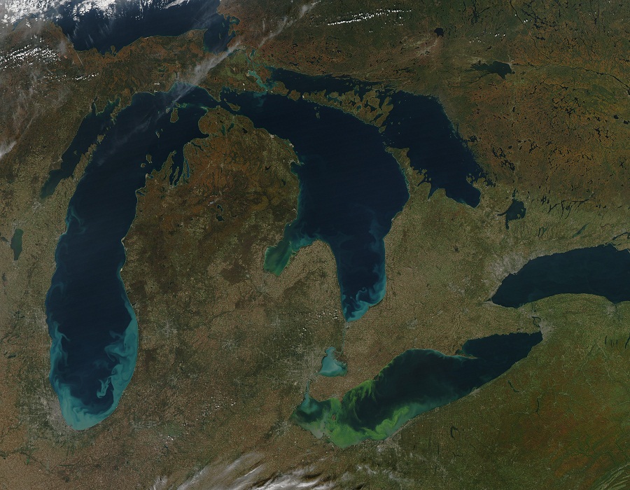
Lake Huron (French: Lac Huron) is one of the five Great Lakes of North America. Hydrologically, it comprises the larger portion of Lake Michigan - Huron. It is bounded on the east by the Canadian province of Ontario and on the west by the state of Michigan in the United States. The name of the lake is derived from early French explorers who named it for the Huron people inhabiting the region.
Lake Huron is the second largest of the Great Lakes, with a surface area of 59,596 km2 (23,010 sq mi) making it the third largest fresh water lake on Earth (fourth largest lake if the saline Caspian Sea is included). It contains a volume of 3,540 km3 (850 cubic miles), and a shoreline length of 3,827 mi (6,159 km).
The surface of Lake Huron is 577 ft (176 m) above sea level. The lake's average depth is 195 ft (59 m), while the maximum depth is 750 ft (229 m). It has a length of 206 mi (332 km) and a greatest breadth of 183 mi (295 km).
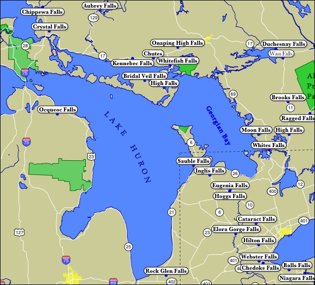
Important cities on Lake Huron include: Goderich, Sarnia, Bay City, Alpena, Rogers City, Cheboygan, St. Ignace, and Port Huron.
A large bay that protrudes northeast from Lake Huron into Ontario, Canada is called Georgian Bay. A notable feature of the lake is Manitoulin Island, which separates the North Channel and Georgian Bay from Lake Huron's main body of water. It is the world's largest fresh water island. A smaller bay that protrudes southwest from Lake Huron into the state of Michigan, USA, is called Saginaw Bay. Historic High Water The
lake fluctuates from month to month with the highest lake levels in
October and November. The normal high water mark is 2.00 feet
(0.61 m) above datum (577.5 ft or 176.0 meters). In the summer of 1986, Lakes Michigan and Huron reached their highest level at 5.92 feet (1.80 m) above datum. The
high water records began in February 1986 and lasted through the year,
ending with January 1987. Water levels ranged from 3.67 feet
(1.12 m) to 5.92 feet (1.80 m) above Chart Datum. Historic Low Water Lake levels tend to be the lowest in winter. The normal low water mark is 1.00 foot (0.30 m) below datum (577.5 ft or 176.0 meters). In the winter of 1964, Lakes Michigan and Huron reached their lowest level at 1.38 feet (0.42 m) below datum. As
with the high water records, monthly low water records were set each
month from February 1964 through January 1965. During this twelve month
period water levels ranged from 1.38 feet (0.42 m) to 0.71 feet
(0.22 m) below Chart Datum.
The Great Lakes Circle Tour is a designated scenic road system connecting all of the Great Lakes and the St. Lawrence River. Lake Huron has the largest shore line length of any of the Great Lakes, counting its 30,000 islands. Lake Huron is separated from Lake Michigan, which lies at the same level, by the narrow Straits of Mackinac, making them geologically and hydrologically the same body of water (sometimes called Lake Michigan - Huron and sometimes described as two 'lobes of the same lake'). Aggregated, Lake Huron - Michigan, at 45,300 sq mi (117,000 km2), "is technically the world's largest freshwater lake." Lake Superior is slightly higher than both. It drains into the St. Marys River at Sault Ste. Marie which then flows southward into Lake Huron. The water then flows south to the St. Clair River, at Port Huron, Michigan and Sarnia, Ontario. The Great Lakes Waterway continues thence to Lake St. Clair; the Detroit River and Detroit, Michigan; into Lake Erie and thence – via Lake Ontario and the St. Lawrence River – to the Atlantic Ocean. Like the other Great Lakes, it was formed by melting ice as the continental glaciers retreated toward the end of the last ice age.
Before this, Lake Huron was a low lying depression through which flowed
the now buried Laurentian and Huronian Rivers; the lake bed was
criss - crossed by a large network of tributaries to these ancient
waterways, with many of the old channels still evident on bathymetric
maps. The
French, the first European visitors to the region, often referred to
Lake Huron as La Mer Douce, "the fresh - water sea". In 1656, a map by
French cartographer Nicolas Sanson, refers to the lake as Karegnondi, a Wendat word which has been variously translated as "Freshwater Sea", "Lake of the Hurons", or simply "lake". The lake was generally labeled "Lac des Hurons" (Lake of the Huron) on most early European maps. On November 9, 1913, a great storm in Lake Huron sank ten ships and more than twenty were driven ashore. The storm, which raged for 16 hours, killed 235 seamen. The Matoa had passed between Port Huron, Michigan and Sarnia, Ontario, just
after midnight. On the 9th, just after six in the morning, the Senator
pushed upstream. Less than an hour later, the Manola passed through.
Captain Frederick W. Light of the Manola reported that both the Canadian
and the American weather stations had storm flag signals flying from
their weather towers. Following
behind at 7:00 a.m. that Sunday, the Regina steamed out of Sarnia into
the northwest gale. The warnings now had been up for four hours. The
Manola passed the Regina off Port Sanilac, 22 miles up the lake.
Captain Light determined that if it continued to deteriorate, he would
seek shelter at Harbor Beach, Michigan,
another 30 miles up the lake. There, he could seek shelter behind the
breakwater. Before reaching Harbor Beach, the winds turned to the
northeast and the lake began to rise. It would be noon before he reached
Harbor Beach and ran for shelter. The waves were so violent that the
Manola touched bottom entering the harbor. With help from a tug, the
Manola tied up to the break wall with eight lines. It was about 3:00
p.m. when the Manola was secured and the crew prepared to drop anchor.
As they worked, the cables began to snap from wind pressure against the
hull. To keep from being pushed aground, they kept their bow into the
wind with the engines running half to full in turns, yet the ship still
drifted 800 feet before its movement was arrested. Waves
breaking over the ship damaged several windows and the crew reported
seeing portions of the concrete break wall peeling off as the waves
struck it. Meanwhile, fifty miles further up the lake, the Matoa, and Captain Hugh McLeod had to ride out the storm without a safe harbor. The Matoa would be found stranded on the Port Austin reef when the winds subsided. It
was noon on Monday before the winds let up and not until 11:00 p.m.
that night before Capt. Light determined it to be safe to continue his
journey. More
than a thousand wrecks have been recorded in Lake Huron. These
purportedly include the first European vessel to sail the Great Lakes, Le Griffon built in 1679 on the eastern shore of Lake Erie, near Buffalo, New York, Sieur de la Salle navigated across Lake Erie, up the Detroit River, Lake St. Clair and the St. Clair River out into Lake Huron. Passing the Straits of Mackinac, La Salle and the Griffon made landfall on Washington Island, off the tip of the Door Peninsula on the Wisconsin side of Lake Michigan. Here, La Salle filled the Griffon with pelts and in late November 1679 sent the Griffon back to the site of modern day Buffalo, never to be seen again. Two wrecks have been identified as the Griffon, although neither has gained final verification as the actual wreck. Blown by a fierce storm after leaving, the Griffon ran aground before the storm. The people of Manitoulin Island say that the wreck in Mississagi Straits at the western tip of the island is that of the Griffon. Meanwhile, others near Tobermory say that the wreck on Russell Island, 150 miles further east in Georgian Bay is that of the Griffin. 185 of 1000+ wrecks are within the waters of Saginaw Bay. Matoa, A propeller freighter, 2,311 gross tons, built 1890, Cleveland, wrecked, 1913, Port Austin Reef Georgian Bay, which is the largest bay on Lake Huron, contains 212 of the 1000 sunk vessels in the lake. Manola, a propeller freighter of 2,325 gross tons. Built in 1890, by the Globe Shipping Company of Cleveland, Ohio.
Operated by the Minnesota Steamship Company (Cleveland) from 1890 – 1901,
by the Pittsburgh Steamship Company from 1901 – 1918. On January 25,
1918, the Manola was sold to the U.S. Shipping Board. It was sold again
in 1920 to the Canada Steamship Lines, Ltd and renamed the Mapledawn. It became stranded on November 20, 1924 on Christian Island in
Georgian Bay. It was headed for Port McNichol, Ontario. It was declared
a total loss after two weeks. Salvagers were able to recover c.75,000
bushels of barley for delivery to Midland, Ontario. Lake Huron has a lake retention time of 22 years. Like
all of the Great Lakes, the ecology of Lake Huron has undergone drastic
changes in the last century. The lake originally supported a native
deepwater fish community dominated by lake trout, which fed on a number of deepwater ciscos as well as sculpins and other native fishes. Several invasive species, including sea lamprey, alewife and rainbow smelt,
became abundant in the lake by the 1930s. The major native top
predator, lake trout, were virtually extirpated from the lake by 1950
due to a combination of overfishing and the effects of sea lamprey.
Several species of deepwater ciscos were also extirpated from the lake
by the 1960s; the only remaining native deepwater cisco is the bloater. Nonnative Pacific salmon have
been stocked in the lake since the 1960s, and lake trout have also been
stocked in an attempt to rehabilitate the species, although little
natural reproduction of stocked trout has been observed. Lake Huron has suffered recently due the introduction of a variety of new invasive species, including zebra and quagga mussels, the spiny water flea, and round gobies. The deepwater demersal fish community of the lake was in a state of collapse by 2006, and a number of drastic changes have been observed in the zooplankton community of the lake. Chinook salmon catches have also been greatly reduced in recent years, and lake whitefish have become less abundant and are in poor condition. These recent changes may be attributable to the new exotic species.