<Back to Index>
- No. 6 North America Lake Michigan, 58K
PAGE SPONSOR
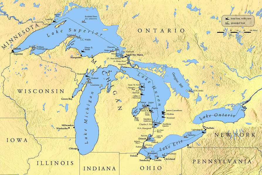
Lake Michigan is one of the five Great Lakes of North America and the only one located entirely within the United States. It is the second largest of the Great Lakes by volume and the third largest by surface area, after Lake Superior and Lake Huron (and is slightly smaller than the US state of West Virginia). Hydrologically, the lake is a large bay of Lake Michigan - Huron, having the same surface elevation as Lake Huron (among other shared properties). It is bounded, from west to east, by the U.S. states of Wisconsin, Illinois, Indiana, and Michigan. The word "Michigan" originally referred to the lake itself, and is believed to come from the Ojibwa word mishigami meaning "great water".
Some of the earliest human inhabitants of the Lake Michigan region were the Hopewell Indians. Their culture declined after 800 A.D., and for the next few hundred years the region was the home of peoples known as the Late Woodland Indians. In the early seventeenth century, when western European explorers made their first forays into the region, they encountered descendants of the Late Woodland Indians: the Chippewa, Menominee, Sauk, Fox, Winnebago, Miami, Ottawa, and Potawatomi. It is believed that the French explorer Jean Nicolet was the first non - Native American to reach Lake Michigan in 1634 or 1638.
With the advent of European exploration into the area in the late 17th century, Lake Michigan became part of a line of waterways leading from the Saint Lawrence River to the Mississippi River and thence to the Gulf of Mexico. French coureurs des bois and voyageurs established small ports and trading communities, such as Green Bay, on the lake during the late 17th and early 18th centuries.
The first person to reach the deep bottom of Lake Michigan was J. Val Klump, a scientist at the University of Wisconsin – Milwaukee. Klump reached the bottom via submersible as part of a 1985 research expedition.
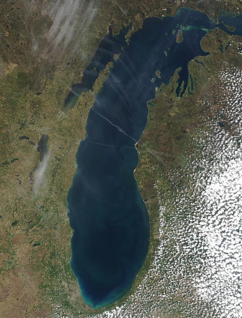
Lake Michigan is the only one of the Great Lakes wholly within the borders of the United States; the others are shared with Canada. It has a surface area of 22,400 square miles (58,000 km2) (58,016 km²), making it the largest lake entirely within one country by surface area (Lake Baikal, in Russia, is larger by water volume), and the fifth largest lake in the world. It is 307 miles (494 km) long by 118 miles (190 km) wide with a shoreline 1,640 miles (2,640 km) long. The lake's average depth is 279 feet (85 m), while its greatest depth is 923 feet (281 m). It contains a volume of 1,180 cubic miles (4,918 km³) of water. Its surface averages 577 feet (176 m) above sea level, the same as Lake Huron, to which it is connected through the Straits of Mackinac.
Twelve million people live along Lake Michigan's shores, mainly in Chicago and Milwaukee. Many small cities in Northern Michigan and Door County, Wisconsin, are centered on a tourist base
that takes advantage of the beauty and recreational opportunities
offered by Lake Michigan. These cities have large seasonal populations
that arrive from the nearby urban areas such as Chicago, Milwaukee, Grand Rapids and Detroit, as well as from Southern states, such as Florida and Texas.
Some seasonal residents have summer homes along the waterfront and
return home for the winter. The southern tip of the lake near Gary, Indiana, is heavily industrialized. The Saint Lawrence Seaway and Great Lakes Waterway opened
the Great Lakes to ocean going vessels. Wider ocean going container
ships do not fit through the locks on these routes and has thus limited
shipping on the lakes. Despite their vast size, large sections of the
Great Lakes freeze in winter, interrupting most shipping. Some
icebreakers ply the lakes. The Great Lakes are also connected by canal to the Gulf of Mexico by way of the Illinois River (from Chicago) and the Mississippi River.
An alternate track is via the Illinois River (from Chicago), to the
Mississippi, up the Ohio, and then through the Tennessee - Tombigbee
Waterway (combination of a series of rivers and lakes and canals), to
Mobile Bay and the Gulf. Commercial tug - and - barge traffic on these
waterways is heavy. Pleasure
boats can also enter or exit the Great Lakes by way of the Erie Canal
and Hudson River in New York. The Erie Canal connects to the Great
Lakes at the east end of Lake Erie (at Buffalo, NY) and at the south
side of Lake Ontario (at Oswego, NY). Lake Michigan has many beaches. The region is often referred to as the "Third Coast" of the United States, after those of the Atlantic Ocean and the Pacific Ocean. The sand is soft and off - white, known as "singing sands" because of the squeaking noise (caused by high quartz content) made when one walks across it. There are often high sand dunes covered in green beach grass and sand cherries, and the water is usually clear and cool (between 55 and 80 °F [13 and 27 °C]), even
in late summer. However, because prevailing westerly winds tend to move
the surface water toward the east, there is a flow of warmer water to
the Michigan shore in the summer. The
sand dunes located on the Michigan shore are the largest freshwater
dune system in the world. In fact, in multiple locations along the
shoreline, the dunes rise several hundred feet above the Lake surface.
Large dune formations can be seen in many state parks, national forests
and national parks along the Indiana and Michigan shoreline. Some of the
most expansive and unique dune formations can be found at Indiana Dunes
National Lakeshore, Saugatuck Dunes State Park, Warren Dunes State
Park, PJ Hoffmaster State Park, Silver Lake State Park, Ludington State
Park and Sleeping Bear Dunes National Lakeshore. Small dune formations
can be found on the western shore of Lake Michigan in Illinois Beach
State Park and moderate sized dune formations can be found in Kohler
Andre State Park and Point Beach State Forest in Wisconsin. A large Dune
formation can be found in Whitefish Dunes State Park in Wisconsin in
the Door Peninsula. Lake Michigan beaches in Northern Michigan are the only place in the world, aside from a few inland lakes in that region, where one can find Petoskey stones, the state stone. The
beaches of the western coast and the northernmost part of the east
coast are rocky, while the southern and eastern beaches are sandy and dune covered.
This is partly because of the prevailing winds from the west which also
cause thick layers of ice to build on the eastern shore in winter. The
Chicago city waterfront is composed of parks, beaches, harbors and
marinas, and residential developments. Where there are no beaches or
marinas, then stone or concrete revetments protect the shoreline from
erosion. The Chicago lakefront is quite walkable as one can stroll past
parks, beaches, and marinas for about 24 miles from the city southern
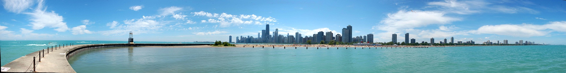
limits with Lake Michigan to its northern city limits point. The Chicago skyline can
be seen from the northwest Indiana shoreline and, on a clear day,
extreme southwestern Michigan. When standing at the waterfront in
Illinois, Wisconsin, and the lower peninsula of Michigan, it is
impossible for one to see directly across the lake to another state.
This gives the lake a view similar to that of an ocean. Viewing a state
across the huge lake is possible from several Chicago skyscrapers. It is
possible from some of the taller buildings in Chicago to make out
points in Indiana and southwest Michigan such as the NIPSCO (Northern Indiana Public Service Company) cooling tower of its power plant in Michigan City, Indiana. The Great Lakes Circle Tour is a designated scenic road system connecting all of the Great Lakes and the St. Lawrence River. Some environmental problems can still plague the lake as steel mills operate near the Indiana shoreline. The Chicago Tribune reported that BP is a major polluter, dumping thousands of pounds of raw sludge into the lake every day from its Whiting, Indiana oil refinery.
People can cross Lake Michigan by the SS Badger, a ferry that runs from Manitowoc, Wisconsin, to Ludington, Michigan. The Lake Express, established in 2004, carries motorists across the lake between Milwaukee, Wisconsin, and Muskegon, Michigan. The National Park Service maintains the Sleeping Bear Dunes National Lakeshore and Indiana Dunes National Lakeshore. Parts of the shoreline are within the Hiawatha National Forest and the Manistee National Forest. The Manistee National Forest section of the shoreline includes the Nordhouse Dunes Wilderness. The Lake Michigan division of the Michigan Islands National Wildlife Refuge is also within the lake. There are numerous state and local parks located on the shores of the lake or on islands within the lake. The Milwaukee Reef, running under Lake Michigan from a point between Milwaukee and Racineto a point between Grand Haven and Muskegon,
divides the lake into northern and southern basins. Each basin has a
clockwise flow of water, deriving from rivers, winds, and the Coriolis effect.
Prevailing westerly winds tend to move the surface water toward the
east, producing a moderating effect on the climate of western Michigan.
There is a mean difference in summer temperatures of 5 to 10 degrees
Fahrenheit (2 to 5 degrees Celsius) between the Wisconsin and Michigan
shores. Hydrologically Michigan and Huron are the same body of water (sometimes called Lake Michigan - Huron), but are geographically distinct. Counted together, it is the largest body of fresh water in the world by surface area. The Mackinac Bridge is generally considered the dividing line between them. Both lakes are part of the Great Lakes Waterway. In earlier maps of the region, the name Lake Illinois has been found in place of "Michigan".