<Back to Index>
- No. 8 Asia Lake Baikal, 31.7K
PAGE SPONSOR
Lake Baikal (Russian: о́зеро Байка́л; Buryat: Байгал нуур, Mongolian: Байгал нуур, Baygal nuur, meaning "nature lake") is the world's oldest at 30 million years old and deepest lake with an average depth of 744.4 metres.
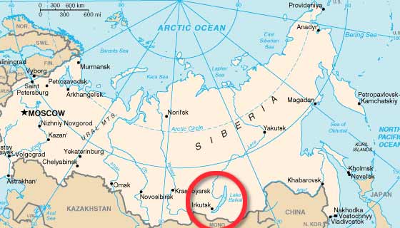
Located in the southern Russian region of Siberia, between Irkutsk Oblast to the northwest and the Buryat Republic to the southeast, it is the most voluminous freshwater lake in the world, containing roughly 20% of the world's unfrozen surface fresh water.
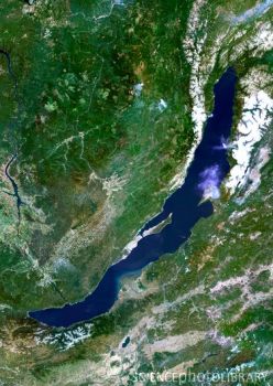
At 1,642 metres (5,387 ft), Lake Baikal is the deepest and among the clearest of all lakes in the world. Similarly to Lake Tanganyika, Lake Baikal was formed as an ancient rift valley, having the typical long crescent shape with a surface area of 31,722 km2 / 12,248 sq mi, less than that of Lake Superior or Lake Victoria. Baikal is home to more than 1,700 species of plants and animals, two thirds of which can be found nowhere else in the world and was declared a UNESCO World Heritage Site in 1996. It is also home to Buryat tribes who reside on the eastern side of Lake Baikal, rearing goats, camels, cattle and sheep, where the regional temperatures vary from a minimum of −19 °C (−2 °F) in winter to maximum of 14 °C (57 °F) in summer. Lake Baikal is nicknamed "Older sister of Sister Lakes (Lake Khövsgöl and Lake Baikal)". Lake Baikal was known as the "North Sea" in historical Chinese texts. It was situated in the then Xiongnu territory. Little was known to Europeans about the lake until Russia expanded into the area in the 17th century. The first Russian explorer to reach Lake Baikal was Kurbat Ivanov in 1643. The Trans - Siberian railway was built between 1896 and 1902. The scenic railway around the southwestern end of Lake Baikal required 200 bridges and 33 tunnels; until its completion, a train ferry transported railcars across the lake (from Port Baikal to Mysovaya)
for a number of years. At times during winter freezes, the lake could
be crossed on foot — though at risk of frostbite and deadly hypothermia
from the cold wind moving unobstructed across flat expanses of ice. A
mass - crossing of military - historical significance (which did indeed
leave many dead from cold exposure) was the 1920 Great Siberian Ice March. Beginning in 1956, the impounding of the Irkutsk Dam on the Angara River raised the level of the lake by 1.4 m (4.6 ft). As the railway was built, a large hydro - geographical expedition headed by F.K. Drizhenko produced the first detailed contour map of the lake bed. Lake Baikal is in a rift valley, created by the Baikal Rift Zone, where the Earth's crust pulls apart. At
636 kilometres (395 mi) long and 79 km (49 mi) wide,
Lake Baikal has the largest surface area of any freshwater lake in Asia (31,722 km2 / 12,248 sq mi)
and is the deepest lake in the world (1,642 m / 5,387 ft). The
bottom of the lake is 1,186.5 metres (3,893 ft) below sea level,
but below this lies some 7 km (4.3 mi) of sediment, placing the rift floor some 8 – 11 kilometres (5.0 – 6.8 mi) below the surface: the deepest continental rift on Earth. In
geological terms, the rift is young and active — it widens about two cm
per year. The fault zone is also seismically active; there are hot
springs in the area and notable earthquakes every few years. The lake is
divided into three basins: North, Central, and South, with depths of
about 900, 1600, and 1400 m, respectively. Fault - controlled
accommodation zones rising to depths of about 300 m separate the basins.
The North and Central basins are separated by Academician Ridge while
the area around the Selenga Delta and the Buguldeika Saddle separates
the Central and South basins. The lake drains into the Angara tributary of the Yenisei. Its age is estimated at 25 – 30 million years, making it one of the most ancient lakes in geological history. It is unique among large, high latitude lakes, in that its sediments have
not been scoured by overriding continental ice sheets. U.S. and Russian
studies of core sediment in the 1990s provide a detailed record of
climatic variation over the past 250,000 years. Longer and deeper
sediment cores are expected in the near future. Lake Baikal is
furthermore the only confined fresh water lake in which direct and
indirect evidence of gas hydrates exists. The lake is completely surrounded by mountains. The Baikal Mountains on the north shore and the taiga are technically protected as a national park. It contains 27 islands; the largest, Olkhon, is 72 km (45 mi) long and is the third largest lake bound island in the world. The lake is fed by as many as three hundred and thirty inflowing rivers. The main ones draining directly into Baikal are the Selenga River, the Barguzin River, the Upper Angara River, the Turka River, the Sarma River and the Snezhnaya River. It is drained through a single outlet, the Angara River. Despite its great depth, the lake's waters are well mixed and well oxygenated throughout the water column, compared to the stratification that occurs in such bodies of water as Lake Tanganyika and the Black Sea. Lake Baikal is rich in biodiversity. It hosts 1,085 species of plants and 1,550 species and varieties of animals. More than 80% of the animals are endemic. Epischura baikalensis is endemic to Lake Baikal and the dominating zooplankton species there, making up 80 to 90 percent of total biomass. The Baikal Seal or nerpa (Pusa sibirica) is found throughout Lake Baikal. It is one of only three entirely fresh water seal populations in the world, the other two being subspecies of Ringed Seal. Perhaps the most important local species is the omul (Coregonus autumnalis migratorius), a smallish endemic salmonid. It is caught, smoked and then sold widely in markets around the lake. Of particular note are the two species of golomyanka or Baikal oil fish (Comephorus baicalensis and C. dybowskii).
These long - finned, translucent fish normally live in depths of
200 – 500 m (650 – 1,600 ft) and are the primary prey of the
Baikal seal, representing the largest fish biomass in the lake. The
Baikal grayling (Thymallus arcticus baicalensis), a fast swimming salmonid, popular among anglers and the Baikal sturgeon (Acipenser baerri baicalensis), are both important endemic species with commercial value. The lake also hosts rich endemic fauna of invertebrates. Among them turbellarian worms, snails and amphipod crustaceans are particularly diverse. The watershed of Lake Baikal has numerous flora species represented. The marsh thistle, Cirsium palustre, is found here at the eastern limit of its geographic range. Several
organizations are carrying out natural research projects on Lake
Baikal. Most of them are governmental or associated with governmental
organizations. The Baikal Research Centre is an independent research organization carrying out environmental educational and research projects at Lake Baikal. In July 2008, Russia sent two small submersibles, Mir-1 and Mir-2,
to descend 1,592 m (5,223 ft) to the bottom of Lake Baikal to
conduct geological and biological tests on its unique ecosystem.
Although originally reported as being successful, they did not set a
world record for the deepest fresh water dive, reaching a depth of only
1,580 m (5,180 ft). That record is currently held by Anatoly Sagalevich, at 1,637 m (5,371 ft) (also in Lake Baikal aboard a Pisces submersible in 1990). Russian scientist and federal politician, Artur Chilingarov, the leader of the mission, also took part in the Mir dives. Russian expansion into the Buryat area around Lake Baikal in 1628 – 1658 was part of the Russian conquest of Siberia. It was done first by following the Angara River upstream from Yeniseysk (founded 1619) and later by moving south from the Lena River. Russians first heard of the Buryats in 1609 at Tomsk. According to folktales related a century after the fact, in 1623, Demid Pyanda, who may have been the first Russian to reach the Lena, crossed from the upper Lena to the Angara and arrived at Yeniseysk. Vikhor Savin (1624) and Maksim Perfilyev (1626 and 1627 – 1628) explored Tungus country on the lower Angara. To the west, Krasnoyarsk on the upper Yenisei was founded in 1627. There were a number of ill documented expeditions eastward from Krasnoyarsk. In 1628 Pyotr Beketov first encountered a group of Buryats and collected yasak from them at the future site of Bratsk.
In 1629 Yakov Khripunov set off from Tomsk to find a rumored silver
mine. His men soon began plundering both Russians and natives. They were
joined by another band of rioters from Krasnoyarsk but left the Buryat
country when they ran short of food. This made it difficult for other
Russians to enter the area. In 1631 Maksim Perfilyev built an ostrog at
Bratsk. The pacification was moderately successful, but in 1634 Bratsk
was destroyed and its garrison killed. (The story goes that the Buryats
did not know how to use firearms, so they decided to burn the muskets
along with the dead Cossacks. The fire caused the guns to go off,
killing a few people which made the Buryats think that the Russians were
still fighting after they were dead.) In 1635 Bratsk was restored by a punitive expedition under Radukovskii. In 1638 it was besieged unsuccessfully. In 1638 Perfilyev crossed from the Angara over the Ilim portage to the Lena River and went downstream as far as Olyokminsk. Returning, he sailed up the Vitim River into
the area east of Lake Baikal (1640) where he heard reports of the Amur
country. In 1641 Verkholensk was founded on the upper Lena. In 1643 Kurbat Ivanov went further up the Lena and became the first Russian to see Lake Baikal and Olkhon Island. Half his party under Skorokhodov remained on the lake, reached the Upper Angara at its northern tip and wintered on the Barguzin River on
the northeast side. In 1644 Ivan Pokhabov went up the Angara to Baikal,
becoming perhaps the first Russian to use this route which is difficult
because of the rapids. He crossed the lake and explored the lower Selenge River. About 1647 he repeated the trip, obtained guides and visited a 'Tsetsen Khan' near Ulan Bator. In 1648 Ivan Galkin built an ostrog on
the Barguzin River which became a center for eastward expansion. In
1652 Vasily Kolesnikov reported from Barguzin that one could reach the
Amur country by following the Selenga, Uda and Khilok Rivers to the
future sites of Chita and Nerchinsk. In 1653 Pyotr Beketov took Kolesnikov's route to Lake Irgen west of Chita and that winter his man Urasov founded Nerchinsk. Next spring he tried to occupy Nerchensk, but was forced by his men to join Stephanov on the Amur. Nerchinsk was destroyed by the local Tungus but restored in 1658.
Since 1993, neutrino research has been conducted at the Baikal Deep Underwater Neutrino Telescope (BDUNT).
The Baikal Neutrino Telescope NT-200 is being deployed in Lake Baikal,
3.6 km (2.2 mi) from shore at a depth of 1.1 km
(0.68 mi). It consists of 192 optical modules (OMs).
The lake, called "the Pearl of Siberia", drew investors from the tourist industry as energy revenues sparked an economic boom. Viktor Grigorov's Grand Baikal in Irkutsk is one of the investors, who planned to build three hotels creating 570 jobs. In 2007, the Russian government declared the Baikal region a special economic zone. The popular resort of
Listvyanka is home to the seven story Hotel Mayak. At the northern part
of the lake Baikal plan (a German NGO) built together with Russians in
2009 the Frolikha Adventure Coastline Track a 100 km long Long distance trail as example for a sustainable development of the region. Baikal was also declared a UNESCO World Heritage site in 1996. Rosatom plans to build a laboratory in Baikal, in conjunction with an international uranium plant and to invest $ 2.5 bn in the region and create 2,000 jobs in the city of Angarsk.
To reach Lake Baikal, there are three main starting points: Irkutsk is on the Angara River which flows out from the southern tip of Lake Baikal. It has the international Irkutsk Airport and is a major stop on the Trans - Siberian Railway (Moscow - Novosibirsk - Taishet - Irkutsk - Vladivostok) and of the Trans - Siberian Highway. Severobaikalsk on the northern tip of Lake Baikal is a relatively new town, on Baikal - Amur Mainline railway (Taishet - Severobaikalsk - Komsomolsk - na - Amure - Sovetskaya Gavan). Its airport is Nizhneangarsk Airport in its adjacent town of Nizhneangarsk. Ulan-Ude is
about 100 km (62 mi) east of Lake Baikal, but one can stop on
the southern shore of the lake on the way to Irkutsk along
the Trans - Siberian Railway or the Trans - Siberian Highway, or on the eastern
shore on the way north to Novy Uoyan along a major road.
Baykalsk Pulp and Paper Mill (BPPM) was constructed in 1966, directly on the shore line, bleaching paper with chlorine and discharging waste into Baikal. After decades of protest, the plant was closed in November 2008 due to unprofitability. In March 2009 the plant owner announced the paper mill would never reopen. However, on 4 January 2010 the production was resumed. On 13 January 2010 Vladimir Putin introduced
changes in the legislation legalising the operation of the mill, which
brought about a wave of protests of ecologists and local residents. This
was based on Putin's visual verification from a mini - submarine "I could
see with my own eyes — and scientists can confirm — Baikal is in good
condition and there is practically no pollution".
Russian oil pipelines state company Transneft was
planning to build a trunk pipeline that would have come within 800
meters (2,600 ft) of the lake shore in a zone of substantial
seismic activity. Environmental activists in Russia, Greenpeace, Baikal pipeline opposition and local citizens were
strongly opposed to these plans, due to the possibility of an
accidental oil spill that might cause significant damage to the
environment. According to the Transneft's president, numerous meetings
with ordinary citizens were held in towns along the route, especially in Irkutsk. However, it was not until Russian president Vladimir Putin ordered
the company to consider an alternative route 40 kilometers (25 mi)
to the north to avoid such ecological risks that Transneft agreed to
alter its plans. Transneft
has since decided to move the pipeline away from Lake Baikal, so that
it will not pass through any federal or republic natural reserves. Work began on the pipeline, two days after President Putin agreed to changing the route away from Lake Baikal. In
2006, the Russian government announced plans to build the world's first
International Uranium Enrichment Centre at an existing nuclear facility
in Angarsk, 95 km (59 mi) from the lake's shores. However,
critics argue it would be a disaster for the region and are urging the
government to reconsider. After enrichment, only 10 percent of the uranium derived radioactive material would be exported to international customers, leaving 90 percent in the Lake Baikal region for storage. Uranium tailings contain
radioactive and toxic materials, which if improperly stored are
potentially dangerous to humans and can contaminate rivers and lakes. In the past, the Baikal was respectfully referred to by many Russians as the "Baikal Sea" (Russian: Море Байкал, More Baikal), rather than merely "Lake Baikal" (Russian: Озеро Байкал, Ozero Baikal). This usage is attested already on the late 17th century maps by Semyon Remezov. To these days, the strait between the western shore of the Lake and the Olkhon Island is called Maloye More (Малое Море), i.e. "the Little Sea". According
to 19th century traveler T.W. Atkinson, locals in the Lake Baikal
Region had the tradition that Christ visited the area: The
people have a tradition in connection with this region which they
implicitly believe. They say "that Christ visited this part of Asia and
ascended this summit, whence he looked down on all the region around.
After blessing the country to the northward, he turned towards the
south, and looking across the Baikal, he waved his hand, exclaiming
'Beyond this there is nothing.'" Thus they account for the sterility of Daouria, where it is said "no corn will grow." Lake
Baikal has been celebrated in several Russian folk songs. Two of these
songs are well known in Russia and its neighboring countries, such as
Japan. The latter song was a secondary theme song for the Soviet Union's second color film, Ballad of Siberia (in Russian: Сказание о земле Сибирской).