<Back to Index>
- No. 9 North America Great Bear Lake, 31.2K
PAGE SPONSOR
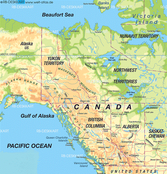
Great Bear Lake (Slavey: Sahtú, French: Grand lac de l'Ours) is the largest lake entirely within Canada (Lake Superior and Lake Huron straddling the Canada - US border are larger), the third or fourth largest in North America, and the seventh or eighth largest in the world. The lake is in the Northwest Territories and is situated on the Arctic Circle between 65 and 67 degrees of northern latitude and between 118 and 123 degrees western longitude, 186 m (610 ft) above sea level.
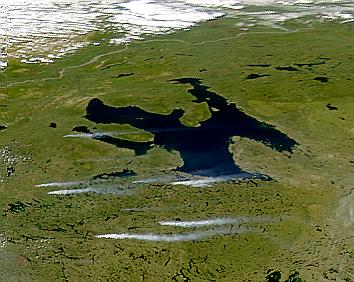
The lake has a surface area of 31,153 km2 (12,028 sq mi) and a total volume of 2,236 km3 (536 cu mi). Its maximum depth is 446 m (1,463 ft) and its average depth 71.7 m (235 ft). The total shoreline is 2,719 km (1,690 mi) and the total catchment area of the lake is 114,717 km2 (44,292 sq mi). The lake empties through the Great Bear River (Sahtúdé) into the Mackenzie River. This lake is surrounded by boreal forest, although the Arctic tundra border lies within 100 mi (160 km) north.
Great Bear Lake lies between two major physiographic regions: the Kazan Uplands portion of the Canadian Shield and the Interior Plains. Originally it was part of the pre-glacial valleys that were reshaped by erosional effects of ice during the Pleistocene. Since then, the lake has undergone various changes resulting from post - glacial rebound following the melting of the ice. Precambrian rocks of the Canadian Shield form the eastern margin of the McTavish Arm. These rocks of the Precambrian are made up of sedimentary and metamorphic deposits supplemented by igneous intrusions forming dikes and sills.
The only community on the lake is Deline at the southwest end, near the Great Bear River, and it is accessed by Déline Airport or, in the summer, Déline Water Aerodrome. As of the 2006 Census the population was 525.
The former Hudson's Bay Company post, Fort Confidence is located on the Dease River which feeds into Dease Arm at the northeast corner.
The mining area known as Port Radium, site of the Eldorado Mine where pitchblende was discovered, is located on the eastern shore.
Fishing is an important income source and there are five fishing lodges located around the lake. One of which, Plummers Great Bear Lake Lodge which is located on the Dease Arm just north of the Arctic Circle, operate both Great Bear Lake Airport and Great Bear Lake Water Aerodrome.
In 1995, a 32.8 kg (72.3 lb) lake trout, the largest ever caught with a rod and reel, was taken on the lake.
In 1930, Gilbert LaBine discovered uranium deposits in the Great Bear Lake region. The Sahtu Dene people took their name from the lake. Great Bear Lake has one ice road, Deline ice road, which links to the community of Tulita.
It is used for few weeks out of the year to deliver supplies to the
remote community of Deline. The road is about 105 km (65 mi)
and follows the Great Bear River. The speed on the ice road is
70 km/h (43 mph) just like the Tuktoyaktuk ice road because there are no portages or stretches of land within the lake. The ice road is used mostly by semi - trailer trucks and
the road usually can handle 64,500 kg (142,000 lb). The road
usually opens around the middle of January and is subject to closure in
late March or early April due to warm weather. From 1960 until 1985 an ice road corridor from Great Slave Lake up
the Marian River, and then down the Camsell River system, serviced
silver mines at Great Bear Lake. This road was constructed by ice road
pioneer John Denison.
Great Bear Lake is covered with ice from late November to July.