<Back to Index>
- North America Mississippi - Missouri - Jefferson, 6275 Km
PAGE SPONSOR
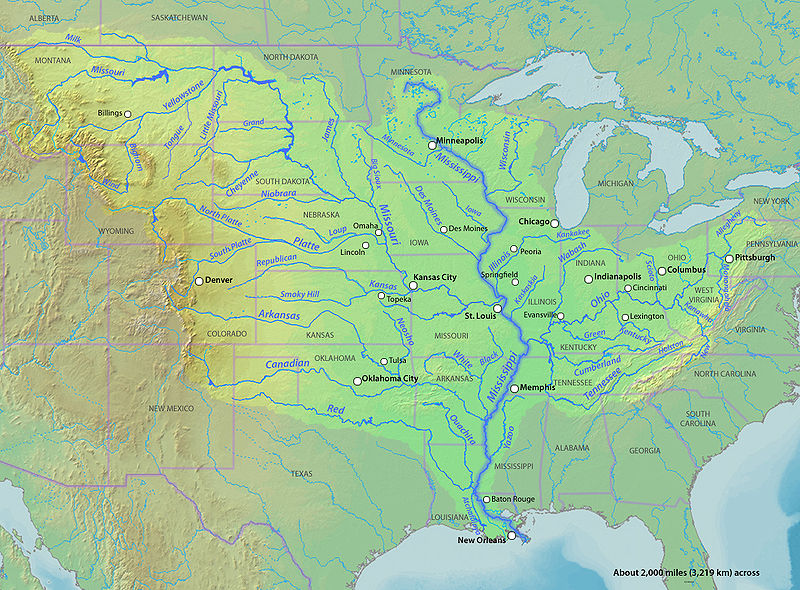
The Mississippi River is the largest river system in North America. Flowing entirely in the United States, this river rises in western Minnesota and meanders slowly southwards for 2,530 miles (4,070 km) to the Mississippi River Delta at the Gulf of Mexico. With its many tributaries, the Mississippi's watershed drains all or parts of 31 U.S. states between the Rocky and Appalachian Mountains and even reaches into southern Canada. The Mississippi ranks fourth longest and tenth largest among the world's rivers.
Native Americans lived along the Mississippi and its tributaries. Most were hunter gatherers or herders, but some such as the Mound builders formed prolific agricultural societies. The arrival of Europeans in the 1500s forever changed the native way of life as first explorers, then settlers, ventured into the basin in increasing numbers. The river served first as barrier – forming borders for New Spain, New France, and the early United States – then as vital transportation artery and communications link. In the 19th century, during the height of Manifest Destiny, the Mississippi and several western tributaries, most notably the Missouri, formed pathways for pioneers partaking in the western expansion of the United States.
Formed from thick layers of this river's silt deposits, the Mississippi River Valley is one of the most fertile agricultural regions of the country and as a result came the rise of the river's storied steamboat era. During the American Civil War, the Mississippi's capture by Union forces marked a turning point towards victory because of this very importance as a route of trade and travel, not least to the Confederacy. Because of substantial growth of cities, and the larger ships and barges that have supplanted riverboats, the decades following the 1900s saw massive engineering works applied to the river system, such as the often in-combination construction of levees, locks and dams.
Since
modern development of the basin began, the Mississippi has also seen
its share of pollution and environmental problems – most notably large volumes of agricultural runoff, which has led to the Gulf of Mexico dead zone off the Delta. In recent years, the river has shown a steady shift towards the Atchafalaya River channel in the Delta; a course change would prove disastrous to seaports such as New Orleans. A system of dikes and gates has so far held the Mississippi at bay, but due to fluvial processes the shift becomes more likely each year.
In addition to historical traditions shown by names, there are at least two other measures of a river's identity, one being the largest branch (by water volume), and the other being the longest branch. Using the largest branch criterion, the Ohio would be the main branch of the Lower Mississippi, not the Middle and Upper Mississippi. Using the longest branch criterion, the Middle Mississippi - Missouri - Jefferson - Beaverhead - Red Rock - Hellroaring Creek River would be the main branch. In either of these cases, the Upper Mississippi from St. Louis, Missouri, to Minnesota, despite its name, would not be part of the more significant branch.
While the Missouri River, flowing from the confluence of the Jefferson, Madison and Gallatin Rivers to the Mississippi, is the longest continuously named river in the United States, the serial combination of Hellroaring Creek and the Red Rock, Beaverhead, Jefferson, Missouri, Middle Mississippi, and Lower Mississippi rivers, considered as one continuous waterway, is the longest river in North America and the third or fourth longest river in the world. Its length of at least 3,745 mi (6,027 km) is exceeded only by the Nile, the Amazon, and perhaps the Yangtze River among the longest rivers in the world. The source of this waterway is at Brower's Spring, 8,800 feet (2,700 m) above sea level in southwestern Montana, along the Continental Divide outside Yellowstone National Park.
The unifying name "Great American River" has been suggested for this multiple named waterway. However, the names "Mississippi River" for the water course from Minnesota to the Gulf of Mexico, "Missouri River" for its major western tributary, and "Ohio River" for its major eastern tributary are so well established that neither reassignment of names nor creation of novel names can be seriously considered as replacements for current usage. Furthermore, the north - south course of the waterway commonly known as the Mississippi River is widely considered a convenient if approximate dividing line between the Eastern, Southern, and Midwestern United States and the Western U.S., as exemplified by the Gateway Arch in St. Louis and the phrase "Trans - Mississippi", used for example in the name of the 1898 Trans - Mississippi Exposition held in Omaha, Nebraska.
The
geographical setting of the Mississippi River includes considerations
of the course of the river itself, its watershed, its outflow, its
prehistoric and historic course changes, and possibilities of future
course changes. The New Madrid Seismic Zone along
the river is also noteworthy. These various basic geographical aspects
of the river in turn underlie its human history and present uses of the
waterway and its adjacent lands.
The Mississippi River is divided into the Upper Mississippi, the Middle Mississippi, and the Lower Mississippi, with the Upper Mississippi upriver of its confluence with the Missouri River, the Middle Mississippi from there downriver to the Ohio River, and the Lower Mississippi from there downriver to the Gulf of Mexico.
The Mississippi River is known as the Upper Mississippi from its headwaters to its confluence with the Missouri River at St. Louis, Missouri. The Upper Mississippi is divided into two sections:
- The headwaters, 493 miles (793 km), from the source to Saint Anthony Falls in Minneapolis, Minnesota;
- A navigable channel, formed by a series of man - made lakes between Minneapolis and St. Louis, Missouri, 664 miles (1,069 km).
The source of the Upper Mississippi branch is traditionally accepted as Lake Itasca, 1,475 feet (450 m) above sea level in Itasca State Park in Clearwater County, Minnesota. The name "Itasca" is a combination of the last four letters of the Latin word for truth (veritas) and the first two letters of the Latin word for head (caput). However, the lake is in turn fed by a number of smaller streams, of which one might be selected as the river's ultimate source.
From its origin at Lake Itasca to St. Louis, Missouri, the waterway's flow is moderated by 43 dams. Fourteen of these dams are located above Minneapolis in the headwaters region and serve multiple purposes, including power generation and recreation. The remaining 29 dams, beginning in downtown Minneapolis, all contain locks and were constructed to improve commercial navigation of the upper river. Taken as a whole these 43 dams significantly shape the geography and influence the ecology of the upper river. Beginning just below Saint Paul, Minnesota, and continuing throughout the upper and lower river, the Mississippi is further controlled by thousands of wing dikes that moderate the river's flow in order to maintain an open navigation channel and prevent the river from eroding its banks.
The head of navigation on the Mississippi is the Coon Rapids Dam in Coon Rapids, Minnesota. Before its construction in 1913, steamboats could occasionally go upstream as far as Saint Cloud, Minnesota, depending on river conditions.
The uppermost lock and dam on the Upper Mississippi River is the Upper St. Anthony Falls Lock and Dam in Minneapolis. Above the dam, the river's elevation is 799 feet (244 m). Below the dam, the river's elevation is 750 feet (230 m). This 49 foot (15 m) drop is the largest of all the Mississippi River locks and dams. The origin of the dramatic drop is a waterfall preserved adjacent to the lock under an apron of concrete. Saint Anthony Falls is the only true waterfall on the entire Mississippi River. The water elevation continues to drop steeply as it passes through the gorge carved by the waterfall.
The Upper Mississippi features various natural and artificial lakes, with its widest point being Lake Winnibigoshish, near Grand Rapids, Minnesota, over 7 miles (11 km) across. Also of note is Lake Onalaska (created by Lock and Dam No. 7), near La Crosse, Wisconsin, over 4 miles (6.4 km) wide. On the other hand, Lake Pepin is natural, formed due to the delta formed by the Chippewa River of Wisconsin as it enters the Upper Mississippi; it is more than 2 miles (3.2 km) wide.
By the time the Upper Mississippi reaches Saint Paul, Minnesota, below Lock and Dam #1, it has dropped more than half its original elevation and is 687 feet (209 m) above sea level. From St. Paul to St. Louis, Missouri, the river elevation falls much more slowly, and is controlled and managed as a series of pools created by 26 locks and dams.
The Upper Mississippi River is joined by the Minnesota River at Fort Snelling in the Twin Cities; the St. Croix River near Prescott, Wisconsin; the Cannon River near Red Wing, Minnesota; the Black River (Mississippi River), La Crosse River, and Root River (Minnesota) in La Crosse, Wisconsin; the Wisconsin River in Prairie du Chien, Wisconsin; the Rock River in the Quad Cities; the Iowa River near Wapello, Iowa; the Skunk River south of Burlington, Iowa; and the Des Moines River in Keokuk, Iowa. Other major tributaries of the Upper Mississippi include the Crow River in Minnesota, the Chippewa River in Wisconsin, the Maquoketa River and the Wapsipinicon River in Iowa, and the Big Muddy River, Illinois River.
The Upper Mississippi is largely a multi - thread stream with many bars and islands. From its confluence with the St. Croix River downstream to Dubuque, Iowa,
the river is entrenched, with high bedrock bluffs lying on either side.
The height of these bluffs decreases to the south of Dubuque, though they are still significant through Savanna, Illinois.
This topography contrasts strongly with the Lower Mississippi, which is
a meandering river in a broad, flat area, only rarely flowing alongside
a bluff (as at Vicksburg, Mississippi).
The Mississippi River is known as the Middle Mississippi from the Upper Mississippi River's confluence with the Missouri River at St. Louis, Missouri, for 190 miles (310 km) to its confluence with the Ohio River at Cairo, Illinois.
The Middle Mississippi is a relatively free flowing river. From St. Louis to the Ohio River confluence, the Middle Mississippi falls a total of 220 feet (67 m) over a distance of 180 miles (290 km) for an average rate of 1.2 feet per mile (23 cm/km). At its confluence with the Ohio River, the Middle Mississippi is 315 feet (96 m) above sea level. Apart from the Missouri River, and the Kaskaskia River in Illinois, no major tributaries enter the Middle Mississippi River.
Measured
by length, the Middle Mississippi's primary branch is the Missouri
River, not the Upper Mississippi, whether or not additional tributaries
upstream are considered. Thus, by length, the main branch of the
Mississippi River system at St. Louis can be considered to be the
Missouri River, rather than the Upper Mississippi. By taking the longer
branch at each significant fork, this continuous but multiply named
waterway can be identified and measured. One name for it is the Lower
& Middle Mississippi - Missouri - Jefferson - Beaverhead - Red
Rock - Hellroaring Creek River. The name "Great American River" has also
been suggested for this longest American waterway.
The Mississippi River is called the Lower Mississippi River from its confluence with the Ohio River to its mouth at the Gulf of Mexico. Measured by water volume, the Lower Mississippi's primary branch is the Ohio River. At the confluence of the Ohio and the Middle Mississippi, the Ohio is the bigger river, with its long - term mean discharge at Cairo, Illinois being 281,500 cu ft/s (7,970 m3/s), while the long - term mean discharge of the Mississippi at Thebes, Illinois (just upriver from Cairo) is 208,200 cu ft/s (5,900 m3/s). Thus, by volume, the main branch of the Mississippi River system at Cairo can be considered to be the Ohio River (and the Allegheny River further upstream), rather than the Middle Mississippi.
In addition to the Ohio River, the major tributaries of the Lower Mississippi River are the White River, flowing in at the White River National Wildlife Refuge in east central Arkansas; the Arkansas River, joining the Mississippi at Arkansas Post; the Big Black River in Mississippi; the Yazoo River, meeting the Mississippi at Vicksburg, Mississippi; and the Red River in Louisiana. The widest point of the Mississippi River is in the Lower Mississippi portion where it exceeds 1 mile (1.6 km) in width in several places.
Due to deliberate water diversion at the Old River Control Structure in Louisiana, the Atchafalaya River in Louisiana is now a major distributary of the Mississippi River, with 30% of the Mississippi's flow routinely being sent to the Gulf of Mexico by this route, rather than continuing down the Mississippi's current channel past Baton Rouge and New Orleans on a longer route to the Gulf.
The Mississippi River has the world's fourth largest drainage basin ("watershed" or "catchment"). The basin covers more than 1,245,000 sq mi (3,220,000 km2), including all or parts of 32 U.S. states and two Canadian provinces. The drainage basin empties into the Gulf of Mexico, part of the Atlantic Ocean. The total catchment of the Mississippi River covers nearly 40% of the landmass of the continental United States.
In the United States, the Mississippi River drains the majority of the area between crest of the Rocky Mountains and the crest of the Appalachian Mountains, except for various regions drained to Hudson Bay by the Red River of the North; to the Atlantic Ocean by the Great Lakes and the Saint Lawrence River; and to the Gulf of Mexico by the Rio Grande, the Alabama and Tombigbee rivers, the Chattahoochee and Appalachicola rivers, and various smaller coastal waterways along the Gulf.
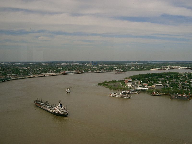
The
Mississippi River empties into the Gulf of Mexico about 100 miles
(160 km) downstream from New Orleans. Measurements of the length of
the Mississippi from Lake Itasca to the Gulf of Mexico vary somewhat,
but the United States Geological Survey's number is 2,340 miles (3,770 km). The retention time from Lake Itasca to the Gulf is typically about 90 days.
The Mississippi River discharges at an annual average rate of between 200 and 700 thousand cubic feet per second (7,000 – 20,000 m3/s). Although it is the 5th largest river in the world by volume, this flow is a mere fraction of the output of the Amazon, which moves nearly 7 million cubic feet per second (200,000 m3/s) during wet seasons. On average, the Mississippi has only 9% the flow of the Amazon River.
Fresh river water flowing from the Mississippi into the Gulf of Mexico does not mix into the salt water immediately. The images from NASA's MODIS show a large plume of fresh water, which appears as a dark ribbon against the lighter blue surrounding waters. These images demonstrate that the plume did not mix with the surrounding sea water immediately. Instead, it stayed intact as it flowed through the Gulf of Mexico, into the Straits of Florida, and entered the Gulf Stream. The Mississippi River water rounded the tip of Florida and traveled up the southeast coast to the latitude of Georgia before finally mixing in so thoroughly with the ocean that it could no longer be detected by MODIS.
Prior to 1900, the Mississippi River transported an estimated 400 million metric tons of sediment per
year from the interior of the United States to coastal Louisiana and
the Gulf of Mexico. During the last two decades, this number was only
145 million metric tons per year. The reduction in sediment transported down
the Mississippi River is the result of engineering modification of the
Mississippi, Missouri, and Ohio rivers and their tributaries by dams, meander cutoffs, river - training structures, and bank revetments and soil erosion control programs in the areas drained by them.
Over geologic time, the Mississippi River has experienced numerous large and small changes to its main course, as well as additions, deletions, and other changes among its numerous tributaries, and the lower Mississippi River has used different pathways as its main channel to the Gulf of Mexico across the delta region.
Through a natural process known as avulsion or
delta switching, the lower Mississippi River has shifted its final
course to the mouth of the Gulf of Mexico every thousand years or so.
This occurs because the deposits of silt and sediment begin to clog its
channel, raising the river's level and causing it to eventually find a
steeper, more direct route to the Gulf of Mexico. The abandoned
distributaries diminish in volume and form what are known as bayous.
This process has, over the past 5,000 years, caused the coastline of
south Louisiana to advance toward the Gulf from 15 to 50 miles (25 –
80 km). The currently active delta lobe is called the Birdfoot
Delta, after its shape, or the Balize Delta, after La Balize, Louisiana, the first French settlement at the mouth of the Mississippi.
The current form of the Mississippi River basin was largely shaped by the Laurentide Ice Sheet of the most recent Ice Age. The southernmost extent of this enormous glaciation extended well into the present day United States and Mississippi basin. When the ice sheet began to recede, hundreds of feet of rich sediment were deposited, creating the flat and fertile landscape of the Mississippi Valley. During the melt, giant glacial rivers found drainage paths into the Mississippi watershed, creating such features as the Minnesota River, James River, and Milk River valleys. When the ice sheet completely retreated, many of these "temporary" rivers found paths to Hudson Bay or the Arctic Ocean, leaving the Mississippi Basin with many features "oversized" for the existing rivers to have carved in the same time period.
Ice sheets during the Illinoian Stage about 300,000 to 132,000 years before present, blocked the Mississippi near Rock Island, Illinois, diverting it to its present channel farther to the west, the current western border of Illinois. The Hennepin Canal roughly follows the ancient channel of the Mississippi downstream from Rock Island to Hennepin, Illinois. South of Hennepin, to Alton, Illinois, the current Illinois River follows the ancient channel used by the Mississippi River before the Illinoian Stage.
In March 1876, the Mississippi suddenly changed course near the settlement of Reverie, Tennessee, leaving a small part of Tipton County, Tennessee, attached to Arkansas and separated from the rest of Tennessee by the new river channel. Since this event was an avulsion, rather than the effect of incremental erosion and deposition, the state line remains located in the old channel.
Geologists consider the next major change in the course of the Lower Mississippi now overdue. Either of two new routes — through the Atchafalaya Basin or through Lake Pontchartrain — might become the Mississippi's main channel if flood - control structures are overtopped or heavily damaged during a severe flood. Such a course change may not be imminent; however, as the Mississippi returned to its present course following the great floods in 2011.
Failure of the Old River Control Structure, the Morganza Spillway, or nearby levees would likely re-route the main channel of the Mississippi through Louisiana's Atchafalaya Basin and down the Atchafalaya River to reach the Gulf of Mexico south of Morgan City in southern Louisiana. This route provides a more direct path to the Gulf of Mexico than the present Mississippi River channel through Baton Rouge and New Orleans. While
the risk of such a diversion is present during any major flood event
(such as those of 1973 or 2011), such a change has so far been prevented
by active human intervention involving the construction, maintenance,
and operation of various levees, spillways, and other control structures
by the U.S. Army Corps of Engineers.
The Old River Control Structure, between the present Mississippi River channel and the Atchafalaya Basin, sits at the normal water elevation and is ordinarily used to divert 30% of the Mississippi's flow to the Atchafalaya River. There is a steep drop here away from the Mississippi's main channel into the Atchafalaya Basin. If this facility were to fail during a major flood, there is a strong concern the water would scour and erode the river bottom enough to capture the Mississippi's main channel. The structure was nearly lost during the 1973 flood, but repairs and improvements were made after engineers studied the forces at play. In particular, the Corps of Engineers made many improvements and constructed additional facilities for routing water through the vicinity. These additional facilities give the Corps much more flexibility and potential flow capacity than they had in 1973, which further reduces the risk of a catastrophic failure in this area during other major floods, such as those of 2011.
Because the Morganza Spillway is located at slightly higher elevation well back from the river, it is normally dry on both sides. Even if this structure were to fail at the crest during a severe flood, the flood waters would have to cause a significant amount of erosion, down to normal water levels, before the Mississippi could permanently jump channel at this location. During the 2011 floods, the Corps of Engineers decided to open the Morganza Spillway to 1/4 of its capacity to allow 150,000 ft3/sec of water to flood the Morganza and Atchafalaya floodways and continue directly to the Gulf of Mexico, bypassing Baton Rouge and New Oreans. In addition to reducing the Mississippi River crest downstream, this diversion is also reducing the chances of a channel change by reducing stress on the other elements of the control system.
Some geologists have noted that the possibility for course change into the Atchafalaya also exists in the area immediately north of the Old River Control Structure. Army Corps of Engineers geologist Fred Smith once stated, "The Mississippi wants to go west. 1973 was a forty - year flood. The big one lies out there somewhere — when the structures can't release all the floodwaters and the levee is going to have to give way. That is when the river's going to jump its banks and try to break through."
If the main channel of the lower Mississippi River changes permanently to the Old River and Atchafalya River channels in the Atchafalaya Basin, thus bypassing Baton Rouge and New Orleans, the ecological and economic consequences for Louisiana, the region, the nation, and international commerce would be immense.
Sedimentation and erosion patterns would quickly change greatly, including development of a new river channel and delta, as well as a new pattern of floodplains, natural levees, and backswamps. Changes to salinity of coastal waters (less saline near new delta, more saline near the present delta) would affect marine life, fisheries, beaches, and coastal marshes. The abandoned river channel would eventually fill and revegetate, probably with a major influx of invasive non - native species. On the other hand, the low lying outer parts of the present delta, lacking replenishment, would mostly soon erode away. Over time, the new channel would itself develop meanders and cutoffs, eventually leading to formation of new oxbow lakes.
Human society would also be greatly altered locally, with broader consequences nationally and globally. Transportation by road, rail, sea, and river barge would all be dramatically affected, and various sizable new bridges would be urgently needed. Existing port facilities may have to be relocated or replaced, and channel alterations would be needed to maintain any substantial degree of commercial shipping on either the new or the old channel of the Mississippi. Power lines, pipelines, and fiber - optic and other communications lines would be similarly disrupted, and housing, agriculture, forestry, petroleum production facilities, and other land uses would be suddenly altered, as would patterns of recreational activities. Morgan City in particular would be quite heavily impacted. Values of many properties would be greatly altered, some increasing, some decreasing, and ownership claims would need to be resolved for the newly exposed land of the old riverbed.
Another possible course change for the Mississippi River is a diversion into Lake Pontchartrain near New Orleans, Louisiana. This route is currently controlled by the he Bonnet Carré Spillway, built to reduce flooding in New Orleans. However, the spillway and an imperfect natural levee about 4 – 6 meters (12 to 20 feet) high are all that prevents the Mississippi from taking a new, shorter course through Lake Pontchartrain to the Gulf of Mexico. Diversion of the Mississippi's main channel through Lake Pontchartrain would have generally similar consequences to an Atchafalaya diversion, but to a lesser extent, since the present river channel would remain in use past Baton Rouge and into the New Orleans area. Following a Lake Pontchartrain diversion, the Mississippi's new delta would develop offshore of southern Mississippi.
The New Madrid Seismic Zone, along the Mississippi River near New Madrid, Missouri, between Memphis and St. Louis, is related to an aulacogen (failed rift) that formed at the same time as the Gulf of Mexico. This area is still quite active seismically. Four great earthquakes in 1811 and 1812, estimated at approximately 8 on the Richter magnitude scale,
had tremendous local effects in the then sparsely settled area, and
were felt in many other places in the midwestern and eastern U.S. These
earthquakes created Reelfoot Lake in
Tennessee from the altered landscape near the river, and temporarily
reversed the direction of flow of the Mississippi itself.
The Mississippi River runs through or along 10 states, from Minnesota to Louisiana, and was used to define portions of these states' borders, with Wisconsin, Illinois, Kentucky, Tennessee, and Mississippi along the east side of the river, and Iowa, Missouri, and Arkansas along its west side. Substantial parts of both Minnesota and Louisiana are on either side of the river, although the Mississippi defines part of the boundary of each of these states.
In
all of these cases, the middle of the riverbed at the time the borders
were established was used as the line to define the borders between
adjacent states. In
various areas, the river has since shifted, but the state borders have
not changed, still following the former bed of the Mississippi River as
of their establishment, leaving several small isolated areas of one
state across the new river channel, contiguous with the adjacent state.
Also, due to a meander in the river, a small part of western Kentucky is
contiguous with Tennessee, but isolated from the rest of its state.
The first bridge across the Mississippi River was built in 1855. It spanned the river in Minneapolis, Minnesota, where the current Hennepin Avenue Bridge is located. No highway or railroad tunnels cross under the Mississippi River.
The first railroad bridge across the Mississippi was built in 1856. It spanned the river between the Rock Island Arsenal in Illinois and Davenport, Iowa. Steamboat captains of the day, fearful of competition from the railroads, considered the new bridge "a hazard to navigation". Two weeks after the bridge opened, the steamboat Effie Afton rammed part of the bridge, catching it on fire. Legal proceedings ensued, with Abraham Lincoln defending the railroad. The lawsuit went to the Supreme Court of the United States and was eventually ruled in favor of the railroad.
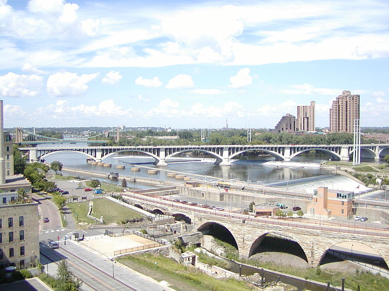
Below is a general overview of selected Mississippi bridges which have notable engineering or landmark significance, with their cities or locations. They are sequenced from the Upper Mississippi's source to the Lower Mississippi's mouth.
- Stone Arch Bridge – Former Great Northern Railway (now pedestrian) bridge at Saint Anthony Falls in downtown Minneapolis.
- I-35W Saint Anthony Falls Bridge – In Minneapolis, opened in September 2008, replacing the I-35W Mississippi River bridge which had collapsed catastrophically on August 1, 2007, killing 13 and injuring over 100.
- I-90 Mississippi River Bridge – Connects La Crosse, Wisconsin, and Winona County, Minnesota, located just south of Lock and Dam No. 7.
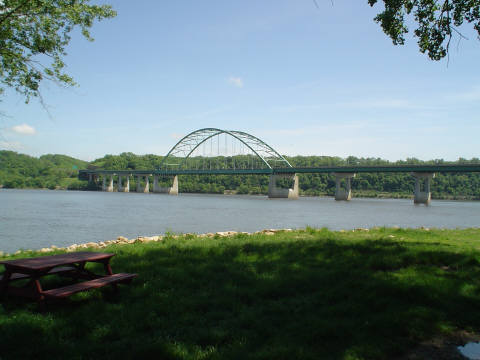
- Black Hawk Bridge – Connects Lansing in Allamakee County, Iowa, and rural Crawford County, Wisconsin; locally referred to as the Lansing Bridge and documented in the Historic American Engineering Record.
- Dubuque - Wisconsin Bridge – Connects Dubuque, Iowa, and Grant County, Wisconsin.
- Julien Dubuque Bridge – Joins the cities of Dubuque, Iowa, and East Dubuque, Illinois; listed in the National Register of Historic Places.
- Savanna - Sabula Bridge – A truss bridge and causeway connecting the city of Savanna, Illinois, and the island city of Sabula, Iowa. The bridge carries U.S. Highway 52 over the river, and is the terminus of both Iowa Highway 64 and Illinois Route 64. Added to the National Register of Historic Places in 1999.
- Fred Schwengel Memorial Bridge – A 4-lane steel girder bridge that connects LeClaire, Iowa, and Rapids City, Illinois. Completed in 1966.
- I-74 Bridge – Connects Bettendorf, Iowa, and Moline, Illinois; originally known as the Iowa - Illinois Memorial Bridge.
- Government Bridge – Connects Rock Island, Illinois and Davenport, Iowa, adjacent to Lock and Dam No. 15; the fourth crossing in this vicinity, built in 1896.
- Rock Island Centennial Bridge – Connects Rock Island, Illinois, and Davenport, Iowa; opened in 1940.
- Norbert F. Beckey Bridge – Connects Muscatine, Iowa, and Rock Island County, Illinois; became first U.S. bridge to be illuminated with light - emitting diode (LED) lights decoratively illuminating the facade of the bridge.
- Great River Bridge – A cable - stayed bridge connecting Burlington, Iowa, to Gulf Port, Illinois.
- Fort Madison Toll Bridge – Connects Fort Madison, Iowa, and unincorporated Niota, Illinois; also known as the Santa Fe Swing Span Bridge; at the time of its construction the longest and heaviest electrified swing span on the Mississippi River. Listed in the National Register of Historic Places since 1999.
- Bayview Bridge – A cable - stayed bridge bringing westbound U.S. Highway 24 over the river, connecting the cities of West Quincy, Missouri, and Quincy, Illinois.
- Quincy Memorial Bridge – Connects the cities of West Quincy, Missouri, and Quincy, Illinois, carrying eastbound U.S. 24, the older of these two U.S. 24 bridges.
- Clark Bridge – A cable - stayed bridge connecting West Alton, Missouri, and Alton, Illinois, also known as the Super Bridge as the result of an appearance on the PBS program, Nova; built in 1994, carrying U.S. Route 67 across the river. This is the northernmost river crossing in the St. Louis metropolitan area, replacing the Old Clark Bridge, a truss bridge built in 1928, named after explorer William Clark.
- Chain of Rocks Bridge – Located on the northern edge of St. Louis, notable for a 22 - degree bend occurring at the middle of the crossing, necessary for navigation on the river; formerly used by U.S. Route 66 to cross the Mississippi.
- Eads Bridge – A combined road and railway bridge, connecting St. Louis and East St. Louis, Illinois. When completed in 1874, it was the longest arch bridge in the world, with an overall length of 6,442 ft (1,964 m). The three ribbed steel arch spans were considered daring, as was the use of steel as a primary structural material; it was the first such use of true steel in a major bridge project.
- Chester Bridge – A truss bridge connecting Route 51 in Missouri with Illinois Route 150, between Perryville, Missouri, and Chester, Illinois. The bridge can be seen in the beginning of the 1967 film In the Heat of the Night. In the 1940s, the main span was destroyed by a tornado.
- Bill Emerson Memorial Bridge — Connecting Cape Girardeau, Missouri, and East Cape Girardeau, Illinois, completed in 2003 and illuminated by 140 lights.
- Hernando de Soto Bridge – A through arch bridge carrying Interstate 40 across the Mississippi between West Memphis, Arkansas, and Memphis, Tennessee.
- Harahan Bridge – A cantilevered through truss bridge, carrying two rail lines of the Union Pacific Railroad across the river between West Memphis, Arkansas, and Memphis, Tennessee.
- Frisco Bridge – A cantilevered through truss bridge, carrying a rail line across the river between West Memphis, Arkansas, and Memphis, Tennessee, previously known as the Memphis Bridge. When it opened on May 12, 1892, it was the first crossing of the Lower Mississippi and the longest span in the U.S. Listed as a Historic Civil Engineering Landmark.
- Memphis & Arkansas Bridge – A cantilevered through truss bridge bridge, carrying Interstate 55 between Memphis and West Memphis; listed on the National Register of Historic Places.
- Helena Bridge
- Greenville Bridge
- Old Vicksburg Bridge
- Vicksburg Bridge
- Natchez - Vidalia Bridge
- John James Audubon Bridge – The longest cable - stayed span in the Western Hemisphere; connects Pointe Coupee and West Feliciana Parishes in Louisiana. It is the only crossing between Baton Rouge and Natchez. This bridge was opened a month ahead of schedule in May 2011, due to the 2011 floods.
- Huey P. Long Bridge – A truss cantilever bridge carrying US 190 (Airline Highway) and one rail line between East Baton Rouge and West Baton Rouge Parishes in Louisiana.
- Horace Wilkinson Bridge – A cantilevered through truss bridge, carrying six lanes of Interstate 10 between Baton Rouge and Port Allen in Louisiana. It is the highest bridge over the Mississippi River.
- Sunshine Bridge
- Gramercy Bridge
- Luling Bridge
- Huey P. Long Bridge – In Jefferson Parish, Louisiana, the first Mississippi River span built in Louisiana.
- Crescent City Connection – Connects the east and west banks of New Orleans, Louisiana; the fifth - longest cantilever bridge in the world.
A clear channel is needed for the barges and other vessels that make the main stem Mississippi one of the great commercial waterways of the world. The task of maintaining a navigation channel is the responsibility of the United States Army Corps of Engineers, which was established in 1802. Earlier projects began as early as 1829 to remove snags, close off secondary channels and excavate rocks and sandbars.
Steamboats entered trade in the 1820s, so the period 1830 – 1850 became the golden age of steamboats. As there were few roads or rails in the lands of the Louisiana Purchase, river traffic was an ideal solution. Cotton, timber and food came down the river, as did Appalachian coal. The port of New Orleans boomed as it was the trans - shipment point to deep sea ocean vessels. As a result, the image of the twin stacked, wedding cake Mississippi steamer entered into American mythology. Steamers worked the entire route from the trickles of Montana, to the Ohio river; down the Missouri and Tennessee, to the main channel of the Mississippi. Only the arrival of the railroads in the 1880s did steamboat traffic diminish. Steamboats remained a feature until the 1920s. Most have been superseded by pusher tugs. A few survive as icons — the Delta Queen and the River Queen for instance.
A series of 29 locks and
dams on the upper Mississippi, most of which were built in the 1930s,
is designed primarily to maintain a 9 feet (2.7 m) deep channel for
commercial barge traffic. The
lakes formed are also used for recreational boating and fishing. The
dams make the river deeper and wider but do not stop it. No flood
control is intended. During periods of high flow, the gates, some of
which are submersible, are completely opened and the dams simply cease
to function. Below St. Louis, the Mississippi is relatively
free - flowing, although it is constrained by numerous levees and directed
by numerous wing dams.
In 1829, there were surveys of the two major obstacles on the upper Mississippi, the Des Moines Rapids and the Rock Island Rapids, where the river was shallow and the riverbed was rock. The Des Moines Rapids were about 11 mi (18 km) long and just above the mouth of the Des Moines River at Keokuk, Iowa. The Rock Island Rapids were between Rock Island and Moline, Illinois. Both rapids were considered virtually impassable.
In 1848, the Illinois and Michigan Canal was built to connect the Mississippi River to Lake Michigan via the Illinois River near Peru, Illinois. The canal allowed shipping between these important waterways. In 1900, the canal was replaced by the Chicago Sanitary and Ship Canal. The second canal, in addition to shipping, also allowed Chicago to address specific health issues (typhoid fever, cholera and other waterborne diseases) by sending its waste down the Illinois and Mississippi river systems rather than polluting its water source of Lake Michigan.
The Corps of Engineers recommended the excavation of a 5 ft (1.5 m) deep channel at the Des Moines Rapids, but work did not begin until after Lieutenant Robert E. Lee endorsed the project in 1837. The Corps later also began excavating the Rock Island Rapids. By 1866, it had become evident that excavation was impractical, and it was decided to build a canal around the Des Moines Rapids. The canal opened in 1877, but the Rock In 1878, Congress authorized the Corps to establish a 4.5 feet (1.4 m) deep channel to be obtained by building wing dams which direct the river to a narrow channel causing it to cut a deeper channel, by closing secondary channels and by dredging. The channel project was complete when the Moline Lock, which bypassed the Rock Island Rapids, opened in 1907.
To improve navigation between St. Paul, Minnesota, and Prairie du Chien, Wisconsin, the Corps constructed several dams on lakes in the headwaters area, including Lake Winnibigoshish and Lake Pokegama. The dams, which were built beginning in the 1880s, stored spring run-off which was released during low water to help maintain channel depth.
In 1907, Congress authorized a 6 feet (1.8 m) deep channel project on the Mississippi, which was not complete when it was abandoned in the late 1920s in favor of the 9 feet (2.7 m) deep channel project.
In 1913, construction was complete on a dam at Keokuk, Iowa,
the first dam below St. Anthony Falls. Built by a private power company
to generate electricity, the Keokuk dam was one of the largest hydro - electric plants in the world at the time. The dam also eliminated the Des Moines Rapids. Lock and Dam No. 1 was completed in Minneapolis, Minnesota, in 1917. Lock and Dam No. 2, near Hastings, Minnesota, was completed in 1930.
Prior to the Great Mississippi Flood of 1927, the Corps' primary strategy was to close off as many side channels as possible to increase the flow in the main river. It was thought that the river's velocity would scour off bottom sediments, deepening the river and decreasing the possibility of flooding. The 1927 flood proved this to be so wrong that communities threatened by the flood began to create their own levee breaks to relieve the force of the rising river.
The
Rivers and Harbors Act of 1930 authorized the 9 feet (2.7 m)
channel project, which called for a navigation channel 9 ft
(2.7 m) deep and 400 ft (120 m) wide to accommodate
multiple - barge tows. This
was achieved by a series of locks and dams, and by dredging.
Twenty - three new locks and dams were built on the upper Mississippi in
the 1930s in addition to the three already in existence.
Until the 1950s, there was no dam below Lock and Dam 26 at Alton, Illinois. Chain of Rocks Lock (Lock and Dam No. 27), which consists of a low - water dam and an 8.4 mi (13.5 km) long canal, was added in 1953, just below the confluence with the Missouri River, primarily to bypass a series of rock ledges at St. Louis. It also serves to protect the St. Louis city water intakes during times of low water.
U.S. government scientists determined in the 1950s that the Mississippi River was starting to switch to the Atchafalaya River channel because of its much steeper path to the Gulf of Mexico. Eventually the Atchafalaya River would capture the Mississippi River and become its main channel to the Gulf of Mexico, leaving New Orleans on a side channel. As a result, the U.S. Congress authorized a project called the Old River Control Structure, which has prevented the Mississippi River from leaving its current channel that drains into the Gulf via New Orleans.
Because
the large scale of high energy water flow threatened to damage the
structure, an auxiliary flow control station was built adjacent to the
standing control station. This US$ 300 million project was completed in
1986 by the U.S. Army Corps Of Engineers. Beginning in the 1970s, the Corps applied hydrological transport models to analyze flood flow and water quality of the Mississippi. Dam 26 at Alton, Illinois,
which had structural problems, was replaced by the Mel Price Lock and
Dam in 1990. The original Lock and Dam 26 was demolished.
The Corps now actively creates and maintains spillways and floodways to divert periodic water surges into backwater channels and lakes, as well as route part of the Mississippi's flow into the Atchafalaya Basin and from there to the Gulf of Mexico, bypassing Baton Rouge and New Orleans. The main structures are the Birds Point - New Madrid Floodway in Missouri; the Old River Control Structure and the Morganza Spillway in Louisiana, which direct excess water down the west and east sides (respectively) of the Atchafalaya River; and the Bonnet Carré Spillway, also in Louisiana, which directs floodwaters to Lake Pontchartrain.
Some of the pre 1927 strategy is still in use today, with the Corps actively cutting the necks of horseshoe bends, allowing the water to move faster and reducing flood heights.
The area of the Mississippi River basin was first settled by hunting and gathering Native American peoples and is considered one the few independent centers of plant domestication in human history. Evidence of early cultivation of sunflower, a goosefoot, a marsh elder and an indigenous squash dates to the 4th millennium BCE. The lifestyle gradually became more settled after around 1000 BCE during what is now called the Woodland period, with increasing evidence of shelter construction, pottery, weaving and other practices. A network of trade routes referred to as the Hopewell interaction sphere was active along the waterways between about 200 and 500 CE, spreading common cultural practices over the entire area between the Gulf of Mexico and the Great Lakes. A period of more isolated communities followed, and agriculture introduced from Mesoamerica based on the Three Sisters (maize, beans and squash) gradually came to dominate. After around 800 CE there arose an advanced agricultural society today referred to as the Mississippian culture, with evidence of highly stratified complex chiefdoms and large population centers. The most prominent of these, now called Cahokia, was occupied between about 600 and 1400 CE and at its peak numbered between 8,000 and 40,000 inhabitants, larger than London, England of that time. At the time of first contact with Europeans, Cahokia and many other Mississippian cities had dispersed, and archaeological finds attest to increased social stress.
Modern American Indian nations inhabiting the Mississippi basin include Cheyenne, Sioux, Ojibwe, Potawatomi, Ho-Chunk, Fox, Kickapoo, Tamaroa, Moingwena, Quapaw and Chickasaw.
The word Mississippi itself comes from Messipi, the French rendering of the Anishinaabe (Ojibwe or Algonquin) name for the river, Misi-ziibi (Great River). The Ojibwe called Lake Itasca Omashkoozo - zaaga'igan (Elk Lake) and the river flowing out of it Omashkoozo - ziibi (Elk River). After flowing into Lake Bemidji, the Ojibwe called the river Bemijigamaag - ziibi (River from the Traversing Lake). After flowing into Cass Lake, the name of the river changes to Gaa - miskwaawaakokaag - ziibi (Red Cedar River) and then out of Lake Winnibigoshish as Wiinibiigoozhish - ziibi (Miserable Wretched Dirty Water River), Gichi - ziibi (Big River) after the confluence with the Leech Lake River, then finally as Misi - ziibi (Great River) after the confluence with the Crow Wing River. After the expeditions by Giacomo Beltrami and Henry Schoolcraft, the longest stream above the juncture of the Crow Wing River and Gichi - ziibi was named "Mississippi River". The Mississippi River Band of Chippewa Indians, known as the Gichi - ziibiwininiwag, are named after the stretch of the Mississippi River known as the Gichi - ziibi. The Cheyenne, one of the earliest inhabitants of the upper Mississippi River, called it the Máʼxe - éʼometaaʼe (Big Greasy River) in the Cheyenne language.
On May 8, 1541, Spanish explorer Hernando de Soto became the first recorded European to reach the Mississippi River, which he called Río del Espíritu Santo ("River of the Holy Spirit"), in the area of what is now Mississippi. In Spanish, the river is called Río Mississippi.
French explorers Louis Jolliet and Jacques Marquette began exploring the Mississippi in the 17th century. Marquette traveled with a Sioux Indian who named it Ne Tongo ("Big river" in Sioux language) in 1673. Marquette proposed calling it the River of the Immaculate Conception.
When Louis Jolliet explored the Mississippi Valley in the 17th century, natives guided him to a quicker way to return to French Canada via the Illinois River. When he found the Chicago Portage, he remarked that a canal of "only half a league" (less than 2 miles (3.2 km), 3 km) would join the Mississippi and the Great Lakes. In 1848, the continental divide separating the waters of the Great Lakes and the Mississippi Valley was breached by the Illinois and Michigan canal via the Chicago River. This both accelerated the development, and forever changed the ecology of the Mississippi Valley and the Great Lakes.
In 1682, René - Robert Cavelier, Sieur de La Salle and Henri de Tonti claimed the entire Mississippi River Valley for France, calling the river Colbert River after Jean - Baptiste Colbert and the region La Louisiane, for King Louis XIV. On March 2, 1699, Pierre Le Moyne d'Iberville rediscovered the mouth of the Mississippi, following the death of La Salle. The French built the small fort of La Balise there to control passage.
In 1718, about 100 miles (160 km) upriver, New Orleans was established along the river crescent by Jean - Baptiste Le Moyne, Sieur de Bienville, with construction patterned after the 1711 resettlement on Mobile Bay of Mobile, the capital of French Louisiana at the time.
Following Britain's victory in the Seven Years War the Mississippi became the border between the British and Spanish Empires. The Treaty of Paris (1763) gave Great Britain rights to all land east of the Mississippi and Spain rights to land west of the Mississippi. Spain also ceded Florida to Britain to regain Cuba, which the British occupied during the war. Britain then divided the territory into East and West Florida.
Article 8 of the Treaty of Paris (1783) states, "The navigation of the river Mississippi, from its source to the ocean, shall forever remain free and open to the subjects of Great Britain and the citizens of the United States". With this treaty, which ended the American Revolutionary War, Britain also ceded West Florida back to Spain to regain the Bahamas, which Spain had occupied during the war. In 1800, under duress from Napoleon of France, Spain ceded an undefined portion of West Florida to France. When France then sold the Louisiana Territory to the US in 1803, a dispute arose again between Spain and the U.S. on which parts of West Florida exactly had Spain ceded to France, which would in turn decide which parts of West Florida were now U.S. property versus Spanish property. These aspirations ended when Spain was pressured into signing Pinckney's Treaty in 1795.
France reacquired 'Louisiana' from Spain in the secret Treaty of San Ildefonso in 1800. The United States then bought the territory from France in the Louisiana Purchase of 1803. In 1815, the U.S. defeated Britain at the Battle of New Orleans, part of the War of 1812, securing American control of the river. So many settlers traveled westward through the Mississippi river basin, as well as settled in it, that Zadok Cramer wrote a guide book called The Navigator, detailing the features and dangers and navigable waterways of the area. It was so popular that he updated and expanded it through 12 editions over a period of 25 years.
The colonization of the area was barely slowed by the three earthquakes in 1811 and 1812, estimated at approximately 8 on the Richter magnitude scale, that were centered near New Madrid, Missouri.
Mark Twain's book, Life on the Mississippi, covered the steamboat commerce which took place from 1830 to 1870 on the river before more modern ships replaced the steamer. The book was published first in serial form in Harper's Weekly in seven parts in 1875. The full version, including a passage from the unfinished Adventures of Huckleberry Finn and works from other authors, was published by James R. Osgood & Company in 1885.
The first steamboat to travel the full length of the Lower Mississippi from the Ohio River to New Orleans was the New Orleans in December 1811. Its maiden voyage occurred during the series of New Madrid earthquakes in 1811 – 12. Steamboat transport remained a viable industry, both in terms of passengers and freight until the end of the first decade of the 20th century. Among the several Mississippi River system steamboat companies was the noted Anchor Line, which, from 1859 to 1898, operated a luxurious fleet of steamers between St. Louis and New Orleans.
Control of the river was a strategic objective of both sides in the American Civil War. In 1862 Union's forces coming down the river successfully cleared Confederate defenses at Island Number 10 and Memphis, Tennessee, while Naval forces coming upriver from the Gulf of Mexico captured New Orleans, Louisiana. The remaining major Confederate stronghold was on the heights overlooking the river at Vicksburg, Mississippi, and the Union's Vicksburg Campaign (December 1862 to July, 1863), and the fall of Port Hudson, completed control of the lower Mississippi River. The Union victory ending the Siege of Vicksburg on July 4, 1863 was pivotal to the Union's final victory of the Civil War.
The "Big Freeze" of 1918 / 19 blocked river traffic north of Memphis, Tennessee, preventing transportation of coal from southern Illinois. This resulted in widespread shortages, high prices, and rationing of coal in January and February.
In the spring of 1927, the river broke out of its banks in 145 places, during the Great Mississippi Flood of 1927 and inundated 27,000 sq mi (70,000 km2) to a depth of up to 30 ft (9.1 m).
On October 20, 1976, the automobile ferry, MV George Prince, was struck by a ship traveling upstream as the ferry attempted to cross from Destrehan, Louisiana, to Luling, Louisiana. Seventy - eight passengers and crew died; only eighteen survived the accident.
In 1988, record low water levels provided an opportunity and obligation to examine the climax of the wooden hulled age. The Mississippi fell to 10 feet (3.0 m) below zero on the Memphis gauge. Water craft remains were exposed in an area of 4.5 acres (18,000 m2) on the bottom of the Mississippi River at West Memphis, Arkansas. They dated to the late 19th to early 20th centuries. The State of Arkansas, the Arkansas Archeological Survey, and the Arkansas Archeological Society responded with a two - month data recovery effort. The fieldwork received national media attention as good news in the middle of a drought.
The Great Flood of 1993 was another significant flood, primarily affecting the Mississippi above its confluence with the Ohio River at Cairo, Illinois.
Two portions of the Mississippi were designated as American Heritage Rivers in 1997: the lower portion around Louisiana and Tennessee, and the upper portion around Iowa, Illinois, Minnesota and Missouri.
In 2002, Slovenian long distance swimmer Martin Strel swam
the entire length of the river, from Minnesota to Louisiana, over the
course of 68 days. In 2005, the Source to Sea Expedition paddled the Mississippi and Atchafalaya Rivers to benefit the Audubon Society's Upper Mississippi River Campaign. On August 1, 2007, the I-35W Mississippi River bridge in Minneapolis collapsed during the evening rush hour. Extensive flooding in April, May, and June 2011 was compared to the Great Mississippi Flood of 1927 and the Great Mississippi and Missouri Rivers Flood of 1993.
The sport of water skiing was invented on the river in a wide region between Minnesota and Wisconsin known as Lake Pepin. Ralph Samuelson of Lake City, Minnesota, created and refined his skiing technique in late June and early July 1922. He later performed the first water ski jump in 1925 and was pulled along at 80 mph (130 km/h) by a Curtiss flying boat later that year.
There are seven National Park Service sites along the Mississippi River. The Mississippi National River and Recreation Area is the National Park Service site dedicated to protecting and interpreting the Mississippi River itself. The other six National Park Service sites along the river are (listed from north to south):
- Effigy Mounds National Monument
- Jefferson National Expansion Memorial (AKA: The Arch)
- Vicksburg National Military Park
- Natchez National Historical Park
- New Orleans Jazz National Historical Park
- Jean Lafitte National Historical Park and Preserve