<Back to Index>
- Central Asia Ob - Irtysh, 5410 Km
PAGE SPONSOR
The Ob River (Russian: Обь), also Obi, is a major river in western Siberia, Russia, and is the world's seventh longest river. It is the westernmost of the three great Siberian rivers that flow into the Arctic Ocean (the other two being the Lena River and the Yenisei River). The Gulf of Ob is the world's longest estuary.
The Ob is known to the Khanty people as the As, Yag, Kolta and Yema; to the Nenets people as the Kolta or Kuay; and to the Siberian Tatars as the Umar or Omass.
The Ob forms 16 miles (26 km) southwest of Biysk in Altai Krai at the confluence of the Biya and Katun rivers. Both these streams have their origin in the Altay Mountains, the Biya issuing from Lake Teletskoye, the Katun, 700 kilometers (430 mi) long, bursting out of a glacier on Mount Byelukha.
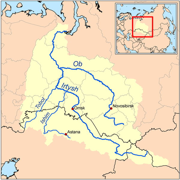
The river splits into more than one arm, especially after joining the large Irtysh tributary at about 69° E. (Originating in China, the Irtysh is actually longer than the Ob from source to the point of their confluence.) From the source of the Irtysh to the mouth of the Ob, the river flow is the longest in Russia at 5,410 kilometers (3,360 mi). Other noteworthy tributaries are: from the east, the Tom, Chulym, Ket, Tym and Vakh rivers; and, from the west and south, the Vasyugan, Irtysh (with the Ishim and Tobol rivers), and Sosva rivers.
The Ob zigzags west and north until it reaches 55° N, where it curves round to the northwest, and again north, wheeling finally eastwards into the Gulf of Ob, a 600 mile (970 km) long bay of the Kara Sea, separating the Yamal Peninsula from the Gydan Peninsula.
The combined Ob - Irtysh system, the third longest river system of Asia (after China's Yangtze and Yellow rivers),
is 5,410 kilometers (3,360 mi) long, and the area of its basin
2,990,000 square kilometers (1,150,000 sq mi). The river basin of
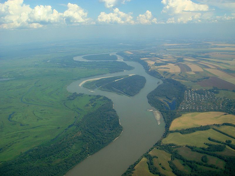
the Ob consists mostly of steppe, taiga, swamps, tundra, and semi - desert topography. The floodplains of the Ob are characterized by many tributaries and lakes. The Ob is ice bound at southern Barnaul from early in November to near the end of April, and at northern Salekhard,
100 miles (160 km) above its mouth, from the end of October to the
beginning of June. The Ob River crosses several climatic zones. The
upper Ob valley, in the south, grows grapes, melons and watermelons,
whereas the lower reaches of the Ob are Arctic tundra. The most
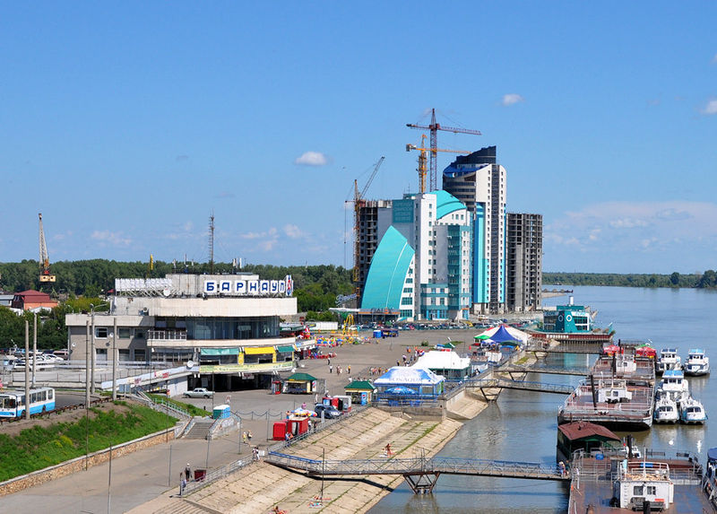
comfortable climate for the rest on the Ob - are Biisk, Barnaul and
Novosibirsk.
The Ob is used mostly for irrigation, drinking water, hydroelectric energy, and fishing; the river has more than 50 species of fish.
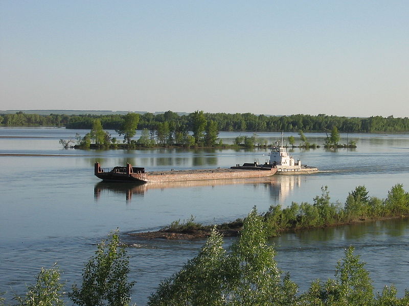
The navigable waters within the Ob basin reach a total length of 9,300 miles (15,000 km). The importance of the Ob basin navigation for transportation was particularly great before the completion of the Trans - Siberian Railway, since, despite the general south - to - north direction of the flow of Ob and most of its tributaries, the width of the Ob basin provided for (somewhat indirect) transportation in the east - west direction as well. Until the early 20th century, a particularly important western river port was Tyumen, located on the Tura River, a tributary of the Tobol. Reached by an extension of the Ekaterinburg - Perm railway in 1885, and thus obtaining a rail link to the Kama and Volga rivers in the heart of Russia, Tyumen became an important railhead for some years until the railway was extended further east. In the eastern reaches of the Ob basin, Tomsk on the Tom River was an important terminus.
Tyumen had its first steamboat in 1836, and the middle reaches of the Ob have been navigated by steamboats since 1845. The first steamboat on the Ob, Nikita Myasnikov's "Osnova", was launched in 1844; but the early starts were difficult, and it was not until 1857 that steamboat shipping started developing in the Ob system in a serious way. Steamboats started operating on the Yenisei in 1863, on the Lena and Amur in the 1870s. In an attempt to extend the Ob navigable system even further, a system of canals, utilizing the Ket River, 560 miles (900 km) long in all, was built in the late 19th century to connect the Ob with the Yenisei, but soon abandoned as being uncompetitive with the railway.
The Trans - Siberian Railway, once completed, provided for more direct, year round transportation in the east - west direction. But the Ob river system still remained important for connecting the huge expanses of Tyumen Oblast and Tomsk Oblast with the major cities along the Trans - Siberian route, such as Novosibirsk or Omsk. In the second half of the 20th century, construction of rail links to Labytnangi, Tobolsk, and the oil and gas cities of Surgut, and Nizhnevartovsk provided more railheads, but did not diminish the importance of the waterways for reaching places still not served by the rail.
A dam was built near Novosibirsk in 1956, which created the then largest artificial lake in Siberia, called Novosibirsk Reservoir.
In the 1960s through 1980s, a gigantic project was contemplated by Soviet engineers and administrators to divert some of the waters of Ob and Irtysh to Kazakhstan and Soviet Central Asian republics, replenishing the Aral Sea as well. The project never left the drawing board, abandoned in 1986 due to economic and environmental considerations.
In the early years of operation, the Mayak plant
released vast quantities of radioactively contaminated water into
several small lakes near the plant. These lakes drain into the Techa River, whose waters ultimately flow into the Ob River.