<Back to Index>
- South East South America Paraná - Río de la Plata, 4880 Km
PAGE SPONSOR
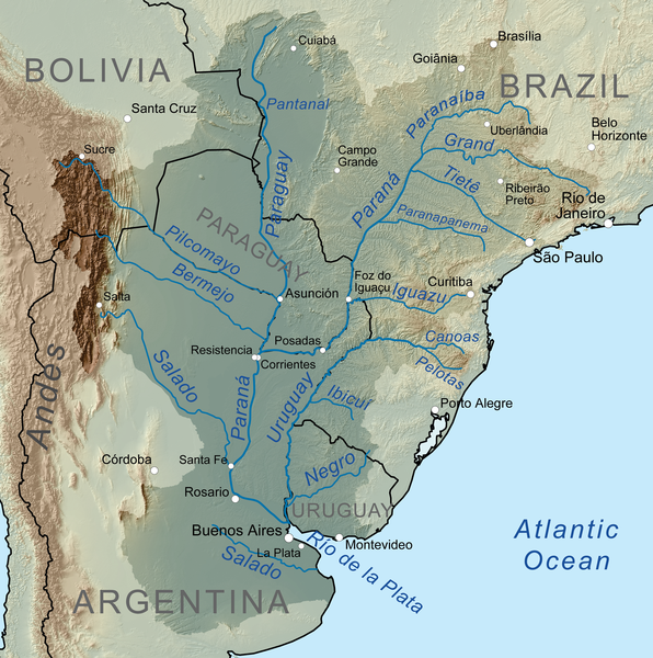
The Paraná River (Spanish: Río Paraná, Portuguese: Rio Paraná) is a river in south Central South America, running through Brazil, Paraguay and Argentina for some 4,880 kilometers (3,030 mi). It is second in length only to the Amazon River among South American rivers. The name Paraná is an abbreviation of the phrase "para rehe onáva", which comes from the Tupi language and means "like the sea" (that is, "as big as the sea"). It merges first with the Paraguay River and then farther downstream with the Uruguay River to form the Río de la Plata and empties into the Atlantic Ocean.
The course is formed at the confluence of the Paranaiba and Grande rivers in southern Brazil. From the confluence the river flows in a generally southwestern direction for about 619 km (385 mi) before encountering the city of Saltos del Guaira, Paraguay. This was once the location of the Sete Quedas waterfall, where the Paraná fell over a series of seven cascades. This natural feature was said to rival the world famous Iguazu Falls to the south. The falls were flooded, however, by the construction of the Itaipu dam, which began operating in 1984.
For approximately the next 200 km (120 mi) the Paraná flows southward and forms a natural boundary between Paraguay and Brazil until the confluence with the Iguazu River. Shortly upstream from this confluence, however, the river is dammed by the impressive Itaipu Dam, the second largest hydroelectric power station in the world (after the Three Gorges Dam in the People's Republic of China), and creating a massive, shallow reservoir behind it.
After merging with the Iguazu, the Paraná then becomes the natural border between Paraguay and Argentina. Overlooking the Paraná River from Encarnación, Paraguay, across the river, is downtown Posadas, Argentina. The river continues its general southward course for about 468 km (291 mi) before making a gradual turn to the west for another 820 km (510 mi), and then encounters the Paraguay River, the largest tributary along the course of the river. Before this confluence the river passes through a second major hydroelectric project, the Yaciretá dam, a joint project between Paraguay and Argentina. The massive reservoir formed by the project has been the source of a number of problems for people living along the river, most notably the poorer merchants and residents in the low lying areas of Encarnación, a major city on the southern border of Paraguay. River levels rose dramatically upon completion of the dam, flooding out large sections of the city's lower areas.
From
the confluence with the Paraguay River, the Paraná again turns
to the south for another approximately 820 km (510 mi) through
Argentina, making a slow turn back to the east near the city of Rosario for the final stretch of less than 500 km (310 mi) before merging with the Uruguay River to form the Río de la Plata and emptying into the Atlantic Ocean. During the part of its course downstream from the city of Diamante, Entre Ríos, it splits into several arms and forms the Paraná Delta, a long flood plain which reaches up to 60 km in width.
The Rio Paraná along with its tributaries creates a massive watershed that spreads throughout much of the south central part of the continent, essentially encompassing all of Paraguay, much of southern Brazil, northern Argentina, and even reaching into Bolivia. If the Uruguay River is counted as a tributary to the Paraná, this watershed extends to cover much of Uruguay as well. The volume of water flowing into the Atlantic Ocean through the Río de la Plata is roughly equal to the volume at the Mississippi River delta. This watershed services a number of large cities, including São Paulo, Buenos Aires, Asunción and Brasília.
The Paraná and its tributaries are a source of income and even daily sustenance for a number of fishermen who live along its banks; some fish species (such as the surubí and the sábalo) are commercially important and exploited for massive internal consumption or for export.
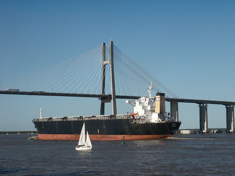
Much of the length of the Paraná is navigable and
is used as an important waterway linking inland cities in Argentina and
Paraguay to the ocean, providing deep water ports in many of these
cities. The construction of massive hydroelectric dams along the river's
length has blocked its use as a shipping corridor to cities further
upstream, but the economic impact of those dams is considered to offset
this. The Yacyretá and Itaipu dams on the Paraguay border have made the small, largely undeveloped nation the world's largest exporter of hydroelectric power.
The Argentine course of the Paraná is crossed by the following bridges, beginning upstream:
- The Friendship Bridge links Ciudad del Este, (Paraguay) and Foz do Iguaçu, (Brazil) and, though not passing over Argentine waters, the bridge is critical for the Triple Frontier area these cities share with Puerto Iguazú, Argentina.
- San Roque González de Santa Cruz Bridge, between Posadas, capital of Misiones Province, Argentina, and Encarnación, Paraguay, capital of the Paraguayan department of Itapúa.
- General Belgrano Bridge between Resistencia (capital of Chaco) and Corrientes (capital of Corrientes).
- Hernandarias Subfluvial Tunnel, which runs under the river between Santa Fe (capital of Santa Fe) and Paraná (capital of Entre Ríos).
- Rosario - Victoria Bridge between Rosario, Santa Fe, and Victoria, Entre Ríos.
- Zárate - Brazo Largo Bridge between Zárate, Buenos Aires and the Province of Entre Ríos.
Additionally, there is a bridge Reconquista, Santa Fe, and Goya, Corrientes, is
under study. Also, as recent as 1998 there were joint studies carried
out by the governments of Uruguay and Argentina for the construction of a
bridge between the two countries over the Río de la Plata estuary, the exact location was not decided.
The Río de la Plata (River of Silver) — sometimes rendered River Plate in British English and the Commonwealth, and occasionally rendered [La] Plata River in other English speaking countries — is the river and estuary formed by the confluence of the Uruguay River and the Paraná River on the border between Argentina and Uruguay. It is a funnel - shaped indentation on the southeastern coastline of South America, about 290 kilometers (180 mi) long.
The
Río de la Plata widens from about 2 kilometers (1.2 mi) at
the inner part to about 220 kilometers (140 mi) at its mouth. It forms part of the border between Argentina and Uruguay, with the major ports and capital cities of Buenos Aires and Montevideo on
its western and northern shores, respectively. The coasts of the
Río de la Plata are the most densely populated areas of Argentina
and Uruguay.
Some geographers consider the Río de la Plata a gulf or marginal sea of the Atlantic Ocean, while others consider it a river. For those who regard it to be a river it is the widest in the world, with a maximum width of about 220 kilometers (140 mi) and a total surface area of about 35,000 square kilometers (14,000 sq mi).
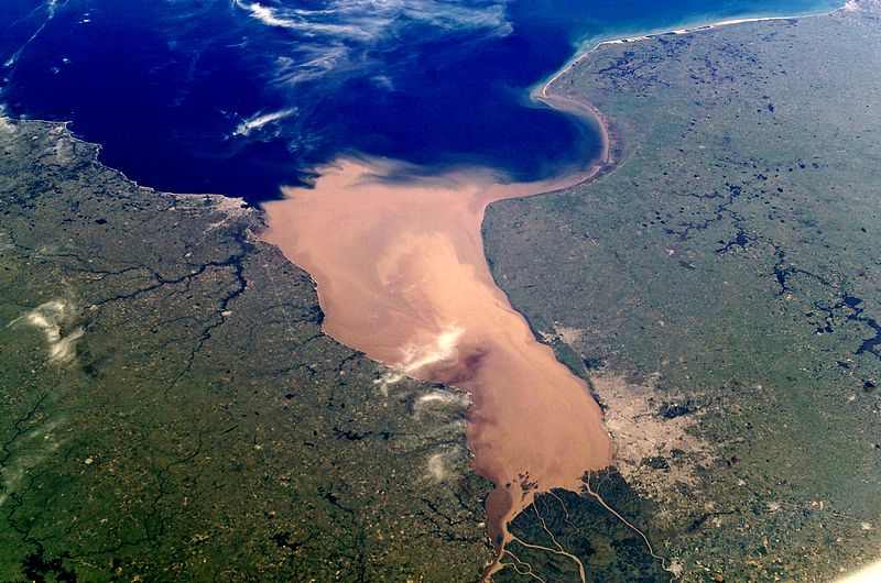
The Río de la Plata behaves as an estuary in which freshwater and seawater mix. Its freshwater comes from the Paraná River, one of the world's longest, and its main tributary, the Paraguay River, as well as the Uruguay River and other smaller streams. Currents in the Río de la Plata are controlled by tides reaching to its source and beyond, into the Uruguay and Paraná rivers. Both rivers are tidally influenced for about 190 kilometers (120 mi). The tidal ranges in the Río de la Plata are small, but its large width allows for a tidal prism important enough to dominate the flow regime despite the huge discharge received by the tributary rivers. The rivers' discharge is strong enough to prevent salt water from penetrating the inner Río de la Plata.
A submerged shoal, the Barra del Indio, acts as a barrier, dividing the Río de la Plata into an inner freshwater riverine area and an outer brackish estuarine area. The shoal is located approximately between Montevideo and Punta Piedras (the northwest end of Samborombón Bay). It is the freshwater of the inner area that causes many to describe the Río de la Plata as a river. The depth of the inner fluvial zone is between about 1 to 5 meters (3.3 to 16 ft). It is about 180 kilometers (110 mi) long and up to 80 kilometers (50 mi) wide. The depth of the outer estuary zone increases from 5 to 25 meters (16 to 82 ft).
The Río de la Plata is a salt wedge estuary. Saltwater, being denser than freshwater, penetrates into the estuary in a layer below the freshwater, which floats on the surface. Salinity fronts, or haloclines, form at the bottom and on the surface, where fresh and brackish waters meet. The salinity fronts are also pycnoclines due to the water density discontinuities. They play an important role in the reproductive processes of fish species.
The International Hydrographic Organization defines the eastern extent of the Río de la Plata as "A line joining Punta del Este, Uruguay and Cabo San Antonio, Argentina".
The Río de la Plata basin is the second largest drainage basin in South America. At a size of about 4,144,000 square kilometers (1,600,000 sq mi), the basin is about one fourth of the continent's surface. It includes areas of southeastern Bolivia, southern and central Brazil, the entire nation of Paraguay, most of Uruguay, and northern Argentina. The main rivers of the La Plata basin are the Paraná, one of the longest in the world, and its main tributary, the Paraguay River, and the Uruguay River.
The Paraná River's main tributaries include the Paranaíba River, Grande River, Corumbá River, Tietê River, Paranapanema river, Iguazu River, Negro River, Carcarañá River, Gualeguay River, and the Salado River. The Paraná River ends in the large Paraná Delta.
The Paraguay's main tributaries include the Jauru River, Cuiabá River, Taquari River, Nabileque River, Curiche Grande River, Apa River, Pilcomayo River, and the Bermejo River. The Paraguay River flows through the Pantanal wetland.
The Uruguay's main tributaries include the Pelotas River, Canoas River, Peperiguaçu River, Ibicuí River, Quaraí River, and the Río Negro.
The rivers of the La Plata Basin carry an estimated 57,000,000 cubic meters (2.0×10⁹ cu ft) of silt into
the Río de la Plata each year, where the muddy waters are
stirred up by winds and tides. The shipping route from the Atlantic to
Buenos Aires is kept open by constant dredging.
The Río de la Plata was first explored by Europeans in 1516, when the Spanish navigator Juan Díaz de Solís traversed it during his search for a passage between the Atlantic and the Pacific Oceans. Juan Díaz de Solís named it the Mar Dulce, or sweet sea. The Portuguese navigator Ferdinand Magellan briefly explored the estuary in 1520 before his expedition continued its circumnavigation.
Sebastian Cabot made a detailed study of the area and renamed it Río de la Plata. He explored the Paraná and Uruguay rivers between 1526 and 1529. He ascended the Paraná as far as the present day city of Asunción, and also explored up the Paraguay River. Trading with the Guaraní near today's Asunción, Cabot acquired silver trinkets, and these objects gave rise to the name Río de la Plata, "river of silver".
The area was visited by Francis Drake's fleet in early 1578, in the early stages of his circumnavigation.
The first European colony was the city of Buenos Aires, founded by Pedro de Mendoza on 2 February 1536. However, it was quickly abandoned. It was refounded by Juan de Garay on 11 June 1580. The failure to establish a settlement on the estuary led to explorations upriver and the founding of Asunción in 1537.
During the colonial era the Río de la Plata was largely neglected by the Spanish Empire until the 1760s, when Portugal and Britain threatened to expand into the estuary. The Spanish Viceroyalty of the Río de la Plata was created in 1776. In 1806 and 1807 the river was the scene of an important British invasion that aimed to occupy the area.
Conflict in the region intensified after the independence of the former Spanish and Portuguese colonies in the first quarter of the 19th century. Interests on the territories and the navigation rights over the Platine region played a major role in many armed conflicts throughout the century, including the Argentine civil wars, the Cisplatine and Platine wars, and the War of the Triple Alliance. The river was blockaded by extra - regional powers on 1838 – 1840 and 1845 – 1850.
In the first naval battle in the Second World War the the German pocket battleship Admiral Graf Spee was engaged by the Royal Navy (RN) cruisers, HMS Exeter, Ajax and Achilles off the estuary of the River Plate The German ship retired up the estuary with a crippled fuel system and put into port at Montevideo. A few days later, rather than fight outgunned, she was scuttled in the estuary - so the battle ended with repairable damage to the British contingent, while the German surface fleet suffered the loss of one its few capital ships.
These events were depicted in the 1956 film The Battle of the River Plate – also known as The Pursuit of the Graf Spee – by Michael Powell and Emeric Pressburger.
The English name "River Plate" is not, as sometimes thought, a mistranslation, as "plate" was used extensively as a noun for "silver" or "gold" from the 12th century onwards, especially in Early Modern English and the estuary has been known as the River Plate or Plate River in English since at least the time of Francis Drake. A modern translation of the Spanish Río de la Plata is "Silver River", referring not to color but to the riches of the fabled Sierra de la Plata thought to lie upstream.
The English version of the name served as an inspiration for one of Argentina's most important football clubs, Club Atlético River Plate.
The Río de la Plata is a habitat for the Loggerhead Sea Turtle, Green Sea Turtle, Leatherback Sea Turtle, the rare La Plata Dolphin, and many species of fish.