<Back to Index>
- South East Asia Amur - Argun, 4444 Km
PAGE SPONSOR
The Amur or Heilong Jiang (Even: Тамур (Tamur), Chinese: 黑龙江; Russian: река Аму́р) is the world's tenth longest river, forming the border between the Russian Far East (Outer Manchuria) and Northeastern China (Inner Manchuria).
It rises in the hills of western Manchuria at the confluence of its two major affluents, the Shilka River and the Ergune River, at an elevation of 303 meters (994 ft). It flows east forming the border between China and Russia, and slowly makes a great arc to the southeast for about 400 kilometers (250 mi), receiving many tributaries and passing many small towns. At Huma, it is joined by a major tributary, the Huma River. Afterwards it continues to flow south until between the cities of Blagoveschensk (Russia) and Heihe (China), it widens significantly as it is joined by the Zeya River, one of its most important tributaries.
The Amur arcs to the east and turns southeast again at the confluence with the Bureya River,
then does not receive another significant tributary for nearly 250
kilometers (160 mi) before its confluence with its largest
tributary, the Songhua River, at Tongjiang. At the confluence with the Songhua the river turns northeast, now flowing towards Khabarovsk, where it joins the Ussuri River and ceases to define the Russia - China border. Now the river spreads out dramatically into a braided character, flowing north - northeast through a wide valley in eastern Russia, passing Amursk and Komsomolsk - on - Amur.
The valley narrows after about 200 kilometers (120 mi) and the
river again flows north onto plains at the confluence with the Amgun River. Shortly after the Amur turns sharply east and into an estuary at Nikolayevsk - on - Amur, about 20 kilometers (12 mi) downstream of which it flows into the Strait of Tartary
In many historical references these two geopolitical entities are known as Outer Manchuria (Russian Manchuria) and Inner Manchuria, respectively. The Chinese province of Heilongjiang on the south bank of the river is named after it, as is the Russian Amur Oblast on the north bank. The name Black River (sahaliyan ula) was used by the Manchu and the Qing Dynasty who always regarded this river as sacred.
The Amur River is a very important symbol of — and an important geopolitical factor in — Chinese - Russian relations. The Amur was especially important in the period of time following the Sino - Soviet political split in the 1960s.
For many centuries the Amur Valley was populated by the Tungusic (Evenki, Solon, Ducher, Nanai, Ulch) and Mongol (Daur) people, and, near its mouth, by the Nivkhs.
For many of them, fishing in the Amur and its tributaries was the main
source of their livelihood. Until the 17th century, these people were
not known to the Europeans, and little known to the Chinese, who
sometimes collectively described them as the Wild Jurchens. The term Yupi Dazi ("Fish
- skin Tatars") was used for the Nanais and related groups as well,
owing to their traditional clothes made of fish skins.
The Mongols, ruling China as the Yuan Dynasty, established a tenuous military presence on the lower Amur in the 13 - 14th centuries; ruins of a Yuan era temple have been excavated near the village of Tyr.
During the Yongle and Xuande era (early 15th century) the Ming Dynasty in China reached the Amur as well in their drive to establish control over the lands adjacent to the Ming Empire from the northeast, which were to become later known as Manchuria. Expeditions headed by the eunuch Yishiha reached Tyr several times between 1411 and the early 1430s, re-building (twice) the Yongning Temple and obtaining at least nominal allegiance of the lower Amur's tribes to the Ming government. Some sources report also the Chinese presence during the same period on the middle Amur, with a fort - a predecessor of later Aigun - existing for about 20 years during the Yongle era on the left (northwestern) shore of the Amur, downstream from the mouth of the Zeya (opposite to the location of the later, Qing, Aigun). In any event, the Ming presence on the Amur was as short lived as it was tenuous; soon after the end of the Yongle reign, the dynasty's frontiers retreated to southern Manchuria.
The 17th century saw the conflict over the control of the Amur between the Russians, expanding into eastern Siberia, and the recently risen Qing Empire, whose original base was in south - eastern Manchuria. Russian Cossack expeditions led by Vassili Poyarkov and Yerofey Khabarov explored the Amur and its tributaries in 1643 - 1644 and 1649 – 1651, respectively. The Cossacks established the fort of Albazin on the upper Amur, at the site of the former capital of the Solons.
At the time, the Qing were busy with conquering China; but a few decades later, during the Kangxi reign they turned their attention to their north Manchurian backyard. Aigun was reestablished near the supposed Ming site ca. 1683 - 1684, and a military expeditions was sent upstream, to dislodge the Russians, whose Albazin establishment deprived the Manchu rulers from the tribute of sable pelts that the Solons and Daurs of the area would supply otherwise. Albazin fell during a short military campaign in 1685. The hostilities were concluded in 1689 by the Treaty of Nerchinsk, which left the entire Amur valley, from the convergence of the Shilka and the Argun downstream, in the Chinese hands.
The Amur region remained a relative backwater of the Qing Empire for the next century and a half, with Aigun being practically the only major town on the river. Russians re-appeared on the river in the mid 19th century, forcing China to yield all lands north of the river to the Russian Empire by the Treaty of Aigun (1858). Lands east of the Ussury and the lower Amur were acquired by Russia as well, by the Convention of Peking (1860).
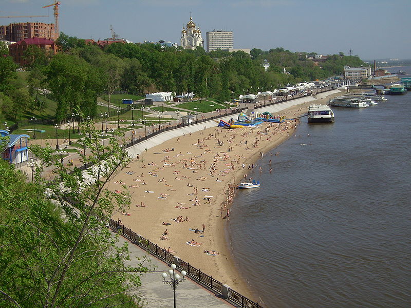
The acquisition of the lands on the Amur and the Ussury was followed by the migration of Russian settlers to the region and the construction of such cities as Blagoveshchensk and, later, Khabarovsk.
Numerous
river steamers plied the Amur by the late 19th century. Mining dredges
were imported from America to work the placer gold of the river. Barge
and river traffic was greatly hindered by the Civil War of 1918 - 22.
The
ex - German Yangtse gunboats Vaterland and Otter, on Chinese Nationalist Navy service, patrolled the Amur in the 1920s.
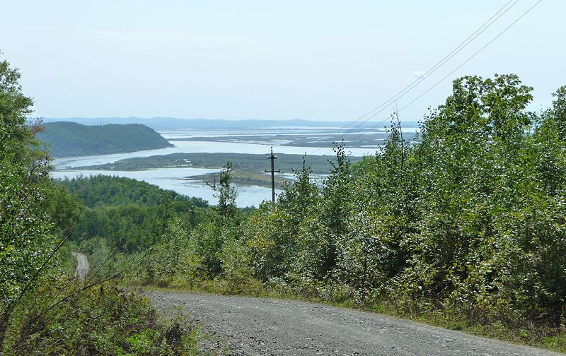
Flowing across northeast Asia for over 4,444 km (2,761 mi), from the mountains of northeastern China to the Sea of Okhotsk (near Nikolayevsk - na - Amure), it drains a remarkable watershed that includes diverse landscapes of desert, steppe, tundra, and taiga, eventually emptying into the Pacific Ocean through the Strait of Tartary, where the mouth of the river faces the northern end of the island of Sakhalin.
The Amur has always been closely associated with the island of Sakhalin at its mouth, and most names for the island, even in the languages of the indigenous peoples of the region, are derived from the name of the river: "Sakhalin" derives from a Tungusic dialectal form cognate with Manchu sahaliyan ("black," as in sahaliyan ula, "Black River"), while Ainu and Japanese "Karaputo" or "Karafuto" is derived from the Ainu name of the Amur or its mouth. Anton Chekhov vividly described the Amur River in writings about his journey to Sakhalin Island in 1890.
The
average annual discharge varies from 6000 m³/s (1980) - 12000
m³/s (1957), leading to an average 9819 m³/s or
310 km³ per year. The maximum runoff measured occurred in Oct
1951 with 30700 m³/s whereas the minimum discharge was recorded in
March 1946 with a mere 514 m³/s.
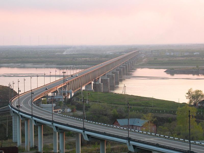
The first permanent bridge across the Amur, the Khabarovsk Bridge, was completed in 1916, allowing the trains on the Trans - Siberian Railway to cross the river year round without using ferries or rail tracks on top of the river ice. In 1941 a railway tunnel was added as well.
Later, a railway bridge over the Amur at Komsomolsk - on - Amur (1975) and a highway bridge at Khabarovsk (1999) were constructed.
Valery Solomonovich Gurevich, government vice - chairman of Russia’s Jewish Autonomous Oblast said that China and Russia started construction of the Amur Bridge Project at the end of 2007. The bridge will link Nizhneleninskoye in the Jewish Autonomous Oblast with Tongjiang in Heilongjiang Province. The 2,197 meter long bridge, with an estimated investment of nearly
US$ 230 million, is expected to be finished by the end of 2010, Gurevich said. Gurevich
said that the proposal to construct a bridge across the river was
actually made by Russia, in view of growing cargo transportation
demands. "The bridge, in the bold estimate, will be finished in three
years," Gurevich said.