<Back to Index>
- Physicist Horace - Bénédict de Saussure, 1740
- Geologist William "Strata" Smith, 1769
PAGE SPONSOR
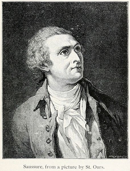
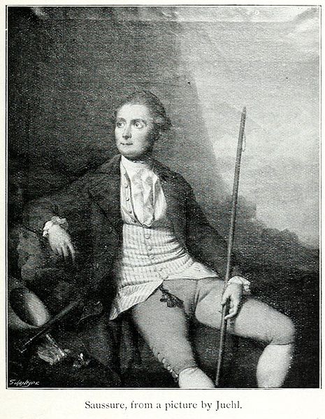
Horace-Bénédict de Saussure (17 February 1740 – 22 January 1799) was a Genevan aristocrat, physicist and Alpine traveler, often considered the founder of alpinism, and considered to be the first person to build a successful solar oven.
Saussure was born in Conches, near Geneva, in 1740.
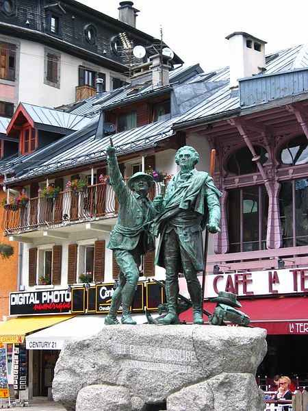
His early interest in botanical studies led him to undertake journeys among the Alps, and from 1773 onwards he directed his attention to the geology and physics of that region. This work did much to clear up the topography of the snowy portions of the Alps, and to attract the attention of tourists to spots like Chamonix and Zermatt.
In 1760 he first visited Chamonix, and offered a reward to the first man to reach the summit of Mont Blanc, at the time unscaled. He made an unsuccessful attempt himself in 1785, by the Aiguille du Goûter route. Two Chamonix men, Dr Michel Paccard and Jacques Balmat attained the summit in 1786, by way of the Grands Mulets, and in 1787 Saussure himself made the third ascent of the mountain.
In 1788 he spent 17 days making observations on the crest of the Col du Géant (3,371 m). In 1774 he mounted the Crammont, and again in 1778, in which year he also explored the Valsorey glacier, near the Great St Bernard in 1776 he had ascended the Buet (3,096m).
In 1789 he climbed the Pizzo Bianco near Macugnaga, to observe the east wall of Monte Rosa, and crossed the Theodulpass (3,322 m) to Zermatt, which he was the first traveler to visit. On that occasion he climbed from the pass up the Klein Matterhorn (3,883m), while in 1792 he spent three days making observations on the same pass without descending to Zermatt, and then visited the Theodulhorn (3,472m).
In 1780 he climbed the Roche Michel, above the Mont Cenis Pass. The descriptions of seven of his Alpine journeys, with his scientific observations gathered en route, were published by him in four quarto volumes, under the general title of Voyages dans les Alpes in 1779 - 1796. There was an octavo issue in eight volumes, issued 1780 - 1796, while the non - scientific portions of the work were first published in 1834, and often since, under the title of Partie pittoresque des ouvrages de M. de Saussure.
The Alps formed the center of Saussure's investigations. He saw them as the grand key to the true theory of the earth, and they gave him the opportunity for studying geology in a manner never previously attempted. The inclination of the strata, the nature of the rocks, the fossils and the minerals received close attention.
He acquired a thorough knowledge of the chemistry of the day; and he applied it to the study of minerals, water and air. Saussure's geological observations made him a firm believer in the Neptunian theory: he regarded all rocks and minerals as deposited from aqueous solution or suspension, and attached much importance to the study of meteorological conditions. His work with rocks, erosion and fossils would also lead him to the idea that the earth was much older than generally thought and formed part of the basis of Darwin's Theory of Evolution.
He carried barometers and boiling point thermometers to
the summits of the highest mountains, and estimated the relative
humidity of the atmosphere at different heights, its temperature, the
strength of solar radiation, the composition of air and its
transparency. Then, following the precipitated moisture, he investigated
the temperature of the earth at all depths to which he could drive his
thermometer staves, the course, conditions and temperature of streams,
rivers, glaciers and lakes, even of the sea.
In the Essai sur l'hygrométrie, published in 1783, he records experiments made with various forms of hygrometer in all climates and at all temperatures, and supports the claims of his hair hygrometer against all others. He invented and improved many kinds of apparatus, including the magnetometer, the cyanometer for estimating the blueness of the sky, the diaphanometer for judging of the clearness of the atmosphere, the anemometer and the mountain eudiometer.
His modifications of the thermometer adapted that instrument to many purposes: for ascertaining the temperature of the air he used one with a fine bulb hung in the shade or whirled by a string, the latter form being converted into an evaporimeter by inserting its bulb into a piece of wet sponge and making it revolve in a circle of known radius, at a known rate; for experiments on the earth and in deep water he employed large thermometers wrapped in non - conducting coatings so as to render them extremely sluggish, and capable of long retaining the temperature once they had attained it.
With these instruments he showed that the bottom water of deep lakes is uniformly cold at all seasons, and that the annual heat wave takes six months to penetrate to a depth of 30 ft. in the earth. He recognized the immense advantages to meteorology of high level observing stations, and whenever it was practicable he arranged for simultaneous observations being made at different altitudes for as long periods as possible.
Saussure was particularly influential as a geologist, and although his ideas on the underlying principles were often erroneous, he was instrumental in greatly advancing that science. He was an early user of the term "geology" — see the "Discours préliminaire" to volume I of his Voyages, published in 1779 — though by no means its inventor as some have claimed, the English word having been used in the 1680s and its Latin counterpart "geologia" during the previous several centuries.
He constructed the first known Western solar oven in 1767, trying several designs before determining that a well insulated box with three layers of glass to trap outgoing thermal radiation created the most heat. The highest temperature he reached was 230°F, which he found did not vary significantly when the box was carried from the top of Mt. Cramont in the Swiss Alps down to the Plains of Cournier, 4,852 feet below in altitude and 34°F above in temperature, thereby establishing that the external air temperature played no significant role in this solar heating effect.
In 1784, he was elected a foreign member of the Royal Swedish Academy of Sciences.
De Saussure died in Geneva in 1799.
The genus of high alpine plants Saussurea, some adapted to growing in some of the most extreme high alpine climates tolerated by any plant, is named after him. The standard botanical author abbreviation Sauss. is applied to species he described.
His work as a mineralogist was also recognized. The Saussurite is named after him.
De Saussure was honored by being depicted on the 20 Swiss franc banknote of the sixth issue of Swiss National Bank notes (1979 - 1995 when replaced by the eighth issue, and the notes were recalled in 2000) (These notes will become valueless on 1 May 2020).
His son Nicolas - Théodore de Saussure was a noted specialist in organic chemistry.
His daughter Albertine Necker de Saussure was a pioneer in the education of women.
In his On the Fourfold Root of the Principle of Sufficient Reason, whilst discussing how reason affects our perception of distance, Arthur Schopenhauer includes an anecdote that "Saussure is reported to have seen so large a moon,
when it rose over Mont Blanc, that he did not recognize it and fainted
with terror".
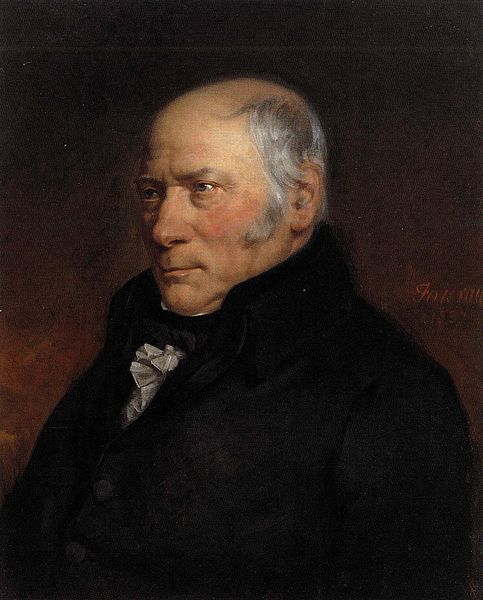
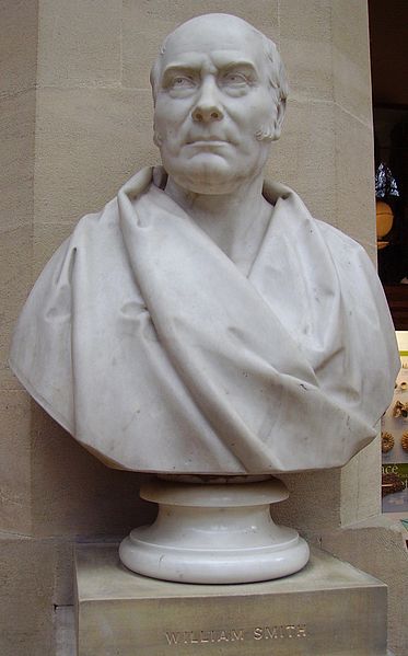
William 'Strata' Smith (23 March 1769 – 28 August 1839) was an English geologist, credited with creating the first nationwide geological map. He is known as the "Father of English Geology" for collating the geological history of England and Wales into a single record, although recognition was very slow in coming. At the time his map was first published he was overlooked by the scientific community; his relatively humble education and family connections preventing him from mixing easily in learned society. Consequently his work was plagiarized, he was financially ruined, and he spent time in debtors' prison. It was only much later in his life that Smith received recognition for his accomplishments.
Smith was born in the village of Churchill, Oxfordshire, the son of blacksmith John Smith, himself scion of a respectable farming family. His father died when Smith was just eight years old, and he was then raised by his uncle. In 1787, he found work as an assistant for Edward Webb of Stow - on - the - Wold, Gloucestershire, a surveyor. He was quick to learn, and soon became proficient at the trade. In 1791, he traveled to Somerset to make a valuation survey of the Sutton Court estate, and building on earlier work in the same area by John Strachey. He stayed there for the next eight years, working first for Webb and later for the Somersetshire Coal Canal Company.
Below is an extract from his writings in which he describes his experiences when living in High Littleton and Bath, Somerset.
Smith worked at one of the estate's older mines, the Mearns Pit at High Littleton, part of the Somerset coalfield and the Somerset Coal Canal. As he observed the rock layers (or strata) at the pit, he realized that they were arranged in a predictable pattern and that the various strata could always be found in the same relative positions. Additionally, each particular stratum could be identified by the fossils it contained, and the same succession of fossil groups from older to younger rocks could be found in many parts of England. Furthermore, he noticed an easterly dip of the beds of rock- small near the surface (about three degrees) then bigger after the Triassic rocks. This gave Smith a testable hypothesis, which he termed The Principle of Faunal Succession, and he began his search to determine if the relationships between the strata and their characteristics were consistent throughout the country. During subsequent travels, first as a surveyor (appointed by noted engineer John Rennie) for the canal company until 1799 when he was dismissed, and later, he was continually taking samples and mapping the locations of the various strata, and displaying the vertical extent of the strata, and drawing cross - sections and tables of what he saw. This would earn him the name "Strata Smith". As a natural consequence, Smith amassed a large and valuable collection of fossils of the strata he had examined himself from exposures in canals, road and railway cuttings, quarries and escarpments across the country. He also developed methods for the identification of deposits of Fuller's earth to the south of Bath.I resided from 1791 - 1795 in a part of the large old manor house belonging to Lady JONES called Rugburn in High Littleton. It was then occupied by a farmer [Cornelius HARRIS], who lodged and boarded me for half a guinea a week and kept my horse for half a crown a week. I have often said that in one respect my residence was the most singular, it being nearer to three cities than any other place in Britain: it is 10 miles from Bath, 10 from Bristol and 12 from Wells. What is called the lower road from Bath to Wells goes through High Littleton but Rugburn old house is a quarter of a mile east of the village and about half way between it and Mearns coal pit. It is a large quadrangular house, I believe with a double M roof; several of the windows used to be darkened [filled up]. There was a square walled court in front with entrance gates between brick pillars on top of a flight of stone steps and on each side of the gates facing the south was a niche in the wall, where I used to sit and study. On the one side of the court was a row of lime trees, which screened it from the farmyard and the east wind, and on the other side was a large walled garden, and over the road of approach there was an avenue of fine elms all across a large piece of pasture. This had been the coach road when the house was occupied, as I understand, by a Major [Capt. John] BRITTON, who, according to the account of the old farmer, was said to have ruined himself by working the coal upon his own estate [BRITTON's half brother, William JONES of Stowey, baled him out with a loan of £1,200, in return for which BRITTON left JONES his High Littleton estates and lordship of the manor on his death in 1742]. I collected much information from the old colliers respecting the coal, ancient collieries, faults re which I must herein omit; but I must be rather particular in describing the house, through it's [sic] relation to the now extensively known science of geology; for, as some of my pupils and friends have called the vicinity of Bath the cradle of geology. I now inform them that RUGBURN WAS IT'S [sic] BIRTHPLACE.
He published his findings with many pictures from his fossil collection, enabling others to investigate their distribution and test his theories. His collection is especially good on Jurassic fossils he collected from the Cornbrash, Kimmeridge clay, Oxford clay, Oolitic limestone and other horizons in the sequence. They included many types of brachiopods, ammonites and molluscs characteristic of the shallow seas in which they were deposited. Some of the names he coined (like Cornbrash) are still used today for this formation.
In 1799 Smith produced the first large scale geologic map of the area around Bath, Somerset. Previously, he only knew how to draw the vertical extent of the rocks, but not how to display them horizontally. However, in the Somerset County Agricultural Society, he found a map showing the types of soils and vegetation around Bath and their geographical extent. Importantly, the differing types were colored. Using this technique, Smith could draw a geological map from his observations showing the outcrops of the rocks. He took a few rock types, each with its own color. Then he estimated the boundaries of each of the outcrops of rock, filled them in with color and ended up with a crude geological map.
In
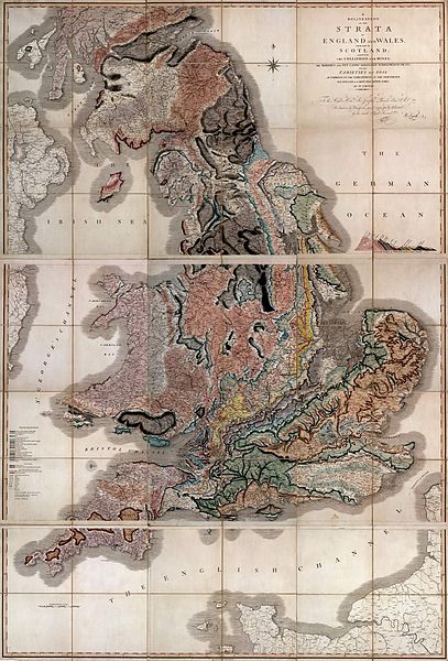
1801, he drew a rough sketch of what would become "The Map that Changed
the World". Because he was unemployed, he could travel across the
length and breadth of the country, while meeting some eminent people
such as Thomas Coke, 1st Earl of Leicester, and the Duke of Bedford.
In 1815 he published the first geological map of Britain. It covered the whole of England and Wales, and parts of Scotland. Conventional symbols were used to mark canals, tunnels, tramways and roads, collieries, lead, copper and tin mines, together with salt and alum works. The various geological types were indicated by different colors; the maps were hand colored. Nevertheless, the map is remarkably similar to modern geological maps of England. He also published his Delineation of the Strata of England in the same year. In another of his books Strata Identified by Organized Fossils (London 1816 - 1819) he recognized that strata contained distinct fossil assemblages which could be used to match rocks across regions.
In 1817 he drew a remarkable geological section from Snowdon to London. Unfortunately, his maps were soon plagiarized and sold for prices lower than he was asking. He went into debt and finally became bankrupt.
On 31 August 1819 Smith was released from King's Bench Prison in London, a debtor's prison. He returned to his home of fourteen years at 15 Buckingham Street to find a bailiff at the door and his home and property seized. Smith then worked as an itinerant surveyor for many years until one of his employers, Sir John Johnstone, recognized him and took steps to gain for him the respect he deserved. Between 1824 and 1826 he lived and worked in Scarborough, and was responsible for the building of the Rotunda, a geological museum devoted to the Yorkshire coast. The Rotunda was re-opened as 'Rotunda – The William Smith Museum of Geology', on 9 May 2008 by Lord Oxburgh, however, the Prince of Wales visited the Rotunda as early as 14 September 2007 to view the progress of the refurbishment of this listed building.
It was not until February 1831 that the Geological Society of London conferred on Smith the first Wollaston Medal in recognition of his achievement. It was on this occasion that the President, Adam Sedgwick, referred to Smith as "the Father of English Geology". Smith traveled to Dublin with the British Association in 1835, and there totally unexpectedly received an honorary Doctorate of Laws (LL.D.) from Trinity College. In 1838 he was appointed as one of the commissioners to select building - stone for the new Palace of Westminster. He died in Northampton, and is buried a few feet from the west tower of St Peter's Church, Marefair.
The inscription on the grave is badly worn but the name "William Smith"
can just be seen. The modern geological map of Britain is based on
Smith's original work, his map being displayed at the Geological Society in London, although now protected by a curtain.
- The first geological map of Britain, much copied in his time, and the basis for all others.
- Geological Surveys around the world owe a debt to his work.
- His nephew John Phillips lived during his youth with William Smith and was his apprentice. John Phillips became a major figure in 19th century geology and paleontology — among other things he's credited as first to specify most of the table of geologic eras that is used today (1841).
- A crater on Mars is named after him.
- The Geological Society of London presents an annual lecture in his honor.
- In 2005, a William Smith 'facsimile' was created at the Natural History Museum as a notable gallery character to patrol its displays, among other luminaries such as Carl Linnaeus, Mary Anning, and Dorothea Bate.