<Back to Index>
- Cartographer and Geographer Liu An, 179 B.C.
- Cartographer and Geographer Pietro Vesconte, 1310
PAGE SPONSOR
Noted for his literary ability, Liu An was reputed to be able to compose an elaborate prose between waking and finishing breakfast. He was a grandson of the founding Han Dynasty (漢朝) emperor Liu Bang (劉邦), and he became the King of Huainan (literally "south of the Huai River"), at the age of 16 after his father, Liu Chang (劉長), died. In a fate similar to his fathers, he committed suicide after a failed coup attempt.
In
addition to composing literary pieces himself, Liu An also frequently
invited other scholars as guests to his estate. Eight scholars in
particular became known as the Eight Immortals of Huainan (淮南八仙). Together, these scholars and Liu An published a treatise in 139 BCE. known as the Huainanzi (淮
南子), translated as "Book of the Master of Huainan", or the "Huainan
Philosophers". This book is considered one of the cornerstones of Daoist philosophy, along with the works of Laozi and Zhuangzi. Along with the earlier Shu Jing (Classic of History) of the 5th century BC (Warring States era), this book provided further concrete information on geography, including descriptions of the topography of China. His book was also concerned with mathematics and music, making use of the "Pythagorean comma" and listing the first known Chinese 12 musical tone tuning.
According to the legend, soy milk was developed by Liu An who made it for his mother who was old and ill but want to taste soybean which her teeth would not be able to chew. Liu An was very troubled by that and the idea of grinding the soybean was actually suggested by his mother, although there is no historical evidence for this legend. In Bencao Gangmu, where Li was attributed to the development of bean curd with no mention of soy milk being invented by anyone, the story was also told by another Ming dynasty writer, Li Yi (李翊), although earlier 10th century writing, the song of bean curd (豆腐詩), already mentioned the method of Huainan in Song dynasty by Zhu Xi. It is also mentioned in a book which mentioned bean curd was called Lai Ki in Han dynasty, and the word appeared in an early Song dynasty writing. While other Chinese sources were found to discredit the Liu An invention theory, stating Liu An lived with a lot of vegetarian monks and the method was taught by them, or it is the Chinese daoists that were recruited by him that used alchemy methods and made both soy milk and bean curd in a more alchemical method as medicines of eternal life, and Liu An is only the powerful noble at that time who can order the mass - production of such items and spread it around, thus making him famous for soy milk and bean curd. Yet most soy bean related work places still place Liu An as the god of bean curd and worship him as the inventor of both soy milk and bean curd.
A
different tradition could be found in 《金華地方風俗志》 and 《中國風俗故事集》mentioning
soy milk and bean curd was made before the Han dynasty and dated it all
the way back to the warring states period by the Yan general Yue Yi. Yet
these two books are rather recent and the quote in them was only a legend
told to bean curd makers through oral tradition without a written record.
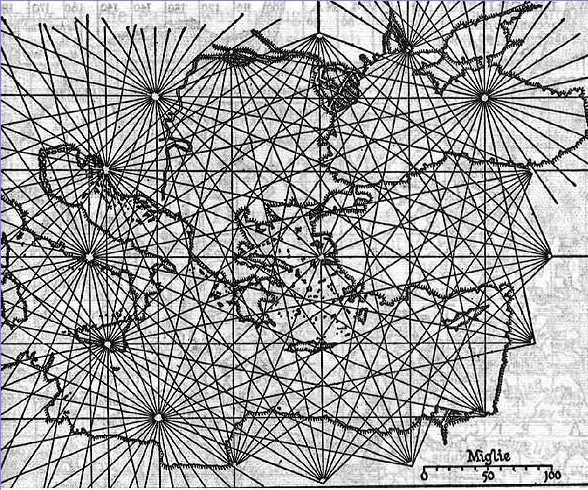
Pietro Vesconte (fl. 1310 – 1330) was a Genoese cartographer and geographer. A pioneer of the field of the portolan chart, he influenced Italian and Catalan map making throughout the fourteenth and fifteenth centuries. He appears to have been the first professional mapmaker to sign and date his works regularly.
Although Vesconte was born in Genoa, he produced much of his work in Venice. He was active between 1310 and 1330, producing numerous maps. His nautical charts are among the earliest to map the Mediterranean and Black Sea regions accurately. He also produced progressively more accurate depictions of the coastlines of northern Europe, in particular that of Britain and, to a lesser extent, Ireland.
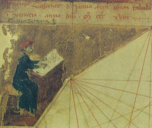
Pietro Vesconte's 1311 portolan chart of the east Mediterranean is the oldest signed and dated nautical chart that survives from the medieval period. He is also the author of at least four signed multi - sheet atlases (1313, 1318a, 1318b, c. 1321), where the various sheets can be combined into a single nautical chart. There is also an atlas (1321) and a solitary portolan chart (1327) signed by "Perrino Vesconte", assumed to be either Pietro himself or possibly a younger relative member of his family using a diminutive form of 'Pietro'. The image of a mapmaker at work, which appears in a Vesconte atlas of 1318, may depict the chartmaker himself.
Pietro Vesconti brought his experience as a maker of portolans to bear on the mappa mundi (circular world map) he produced, which introduced a previously unheard of accuracy to the genre. He provided a world map, nautical atlas, a map of the Holy Land and plan of Acre and Jerusalem for inclusion in Marino Sanuto's Liber secretorum fidelium cruces, a work which aimed to encourage a new crusade. There are three known copies of Sanuto's Liber (c.
1320 – 21, c. 1321, c. 1325) that include Vesconte's maps, only the first
of which is signed; the latter two are confidently assumed to have been
done by him, or at least under his direction.
The following works have been signed or attributed to Pietro Vesconte.
- 1311 dated & signed portolan chart of the east Mediterranean, held (C.N.1) by the Archivio di Stato in Florence, Italy.
- 1313 dated & signed atlas of six sheets held (DD 687) by the Bibliotheque Nationale de France in Paris, France. (1. calendar, 2. Black Sea, 3. Aegean Sea, 4. east Mediterranean, 5. central Mediterranean, 6. west Mediterranean and British Isles)
- 1318 dated & signed atlas of seven sheets held (Port. 28) by Museo Correr in Venice, Italy. (1 calendar, 2. Black Sea, 3. east Medit., 4. central Med., 5. west Med, 6. Spain and north Africa, 7. north Atlantic)
- 1318 dated & signed atlas of ten sheets held (MS 594) by Österreichische Nationalbibliothek in Vienna, Austria. (1.calendar, 2. Black Sea, 3. east Medit., 4. central Medit. (south), 6. central Medit. (north) 7. west Medit., 8. Spain and French Atlantic coast, 9. British Isles, 10. Adriatic Sea)
- c.1320 - 21 undated but signed by Vesconti, for Marino Sanudo's Liber secretorum, mappa mundi plus atlas of five sheets (partially missing), held (Pal.Lat.1362A) by the Bibliotheca Apostolica in Vatican City (2. Black sea, 3. Aegean, 4. Palestine & east Medit. 5. Adriatic and North Africa, 6. west Medit and north Atlantic)
- 1321 dated and signed Perrino Vesconte, atlas of five sheets held (R.P.4) by the Zentralbibliothek in Zurich, Switzerland. (1 calendar, 2. Spain and north Atlantic, 3. central Medit., 4. east Medit. 5. Black Sea)
- c.1321 undated atlas of nine sheets held (MS 175) by the Bibliothèque municipale in Lyons, France. (1. calendar, 2. rhumb network, 3. Black Sea, 4. east Medit., 5. central Medit (north), 6. central Medit (north) 7. west Medit. 8. British Isles & France, 9. Adriatic Sea)
- c.1321 undated and unsigned, confidently attributed to Vesconte, for Marino Sanudo's Liber secretorum, mappa mundi and atlas of five sheets held (Vat. Lat. 2972) by the Bibliotheca Apostolica in Vatican City (1. Black Sea, 2. Aegean and north Africa, 3. Palestine & east Medit. 4. central medit,5. west Medit and north Atlantic)
- c.1325 undated and unsigned, confidently attributed to Vesconte, for Marino Sanudo's Liber secretorum, mappa mundi and atlas of five sheets, held (Add MS 27376) by the British Library, in London, UK. (1. Spain and north Atlantic, 2. central Medit., 3. Palestine & east Medit., 4. Aegean & north Africa, 5. Black Sea)
- 1327 dated and signed Perrino Vesconte, portolan chart, held (Med Palat.248) by the Biblioteca Medicea Laurenziana in Florence, Italy.