<Back to Index>
- Tectonic Plate Indian Plate
- Tectonic Plate Juan de Fuca Plate
- Tectonic Plate Nazca Plate
PAGE SPONSOR
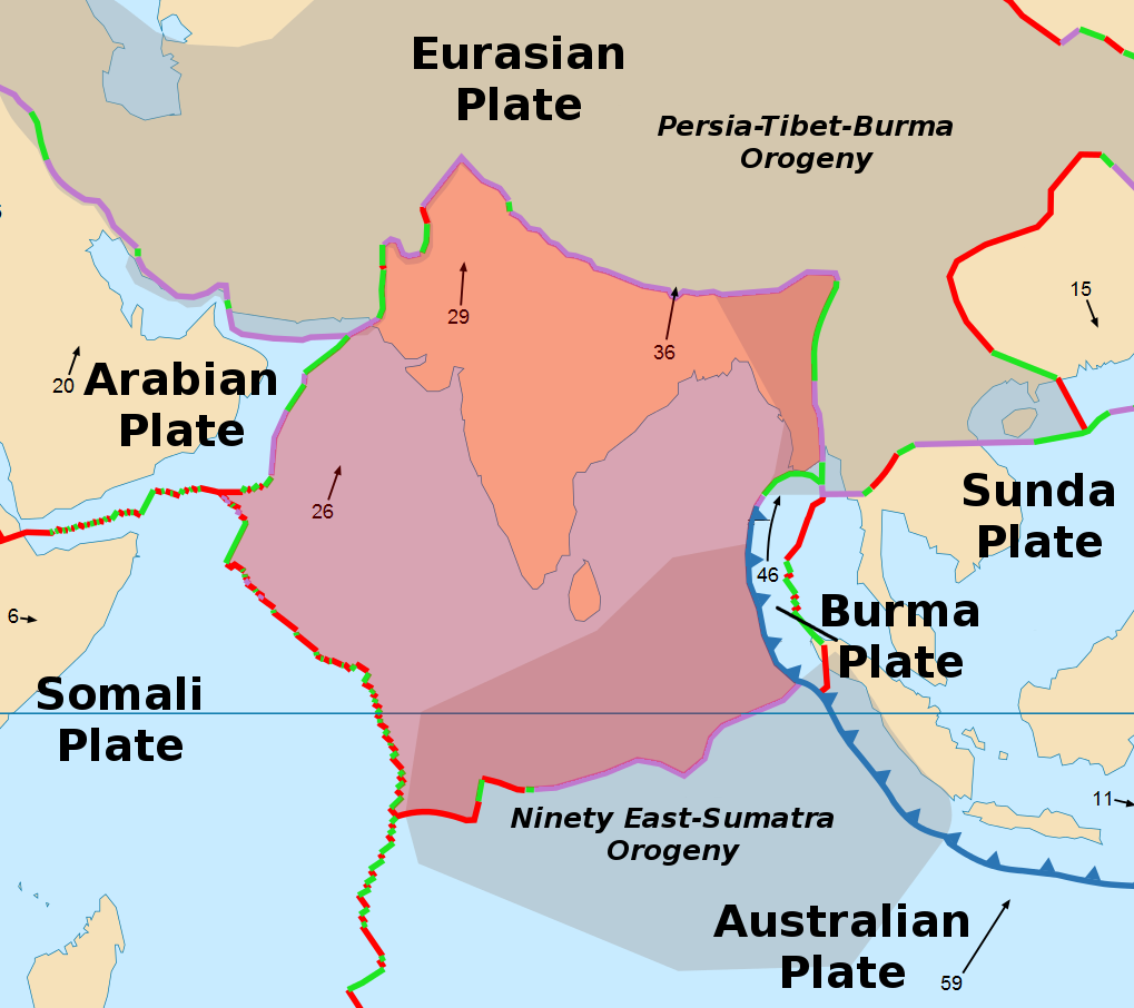
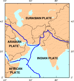
The India Plate or Indian Plate is a tectonic plate that was originally a part of the ancient continent of Gondwanaland from which it split off, eventually becoming a major plate. About 55 to 50 million years ago (contested), it fused with the adjacent Australian Plate. It is today part of the major Indo - Australian Plate, and includes most of South Asia and a portion of the basin under the Indian Ocean, including parts of South China and Eastern Indonesia, and extending up to but not including Ladakh, Kohistan and Balochistan.
140 million years ago the Indian Plate formed part of the supercontinent Gondwanaland together with modern Africa, Australia, Antarctica and South America. Gondwanaland broke up as these continents drifted apart with different velocities, a process which lead to the opening of the Indian Ocean.
In the late Cretaceous about 90 million years ago, subsequent to the splitting off from Gondwanaland of conjoined Madagascar and India, the Indian Plate split from Madagascar. It began moving north, at about 20 centimeters (7.9 in) per year, and is believed to have begun colliding with Asia between 55 and 50 million years ago, in the Eocene epoch of the Cenozoic, although this is contested, with some authors suggesting it was much later at around 35 million years ago. If the collision occurred between 55 and 50 Ma, the Indian Plate would have covered a distance of 3,000 to 2,000 kilometers (1,900 to 1,200 mi), moving faster than any other known plate.
In 2007, German geologists suggested that the reason the Indian Plate moved so quickly is that it is only half as thick (100 kilometers (62 mi)) as the other plates which formerly constituted Gondwanaland. The mantle plume that once broke up Gondwanaland might also have melted the lower part of the Indian subcontinent, which allowed it to move both faster and further than the other parts. The remains of this plume today form the Marion, Kerguelen and Réunion hotspots. As India moved north, it is possible that the thickness of the Indian plate degenerated further as it passed over the hotspots and magmatic extrusions associated with the Deccan and Rajmahal Traps.
The collision with the Eurasian Plate along the boundary between India and Nepal formed the orogenic belt that created the Tibetan Plateau and the Himalaya Mountains, as sediment bunched up like earth before a plow.
The Indian Plate is currently moving north - east at 5 centimeters
(2.0 in) per year, while the Eurasian Plate is moving north at only 2
centimeters (0.79 in) per year. This is causing the Eurasian Plate to
deform, and the India Plate to compress at a rate of 4 millimeters
(0.16 in) per year.
The 9.1 - 9.3 moment magnitude 2004 Indian Ocean earthquake was caused by the release of stresses built up along the subduction zone where the Indian Plate is sliding under the Burma Plate in the eastern Indian Ocean, at a rate of 6 cm/yr (2.5 in/yr). The Sunda Trench is formed along this boundary where the Indo - Australian and Eurasian Plates meet. Earthquakes in the region are either caused by thrust faulting, where the fault slips at right angles to the trench; or strike - slip faulting, where material to the east of the fault slips along the direction of the trench.
Like all similarly large earthquakes, the December 26, 2004 event was caused by thrust - faulting. A 100 kilometers (62 mi) rupture caused about 1,600 kilometers (990 mi) of the interface to slip, which moved the fault 15 metres (49 ft) and lifted the sea floor several meters (yards), creating the great tsunami.
On October 8, 2005, an earthquake of magnitude 7.6 occurred near
Muzaffarabad, Kashmir, Pakistan, killing more than 80,000 people, and
leaving more than 2.5 million homeless.
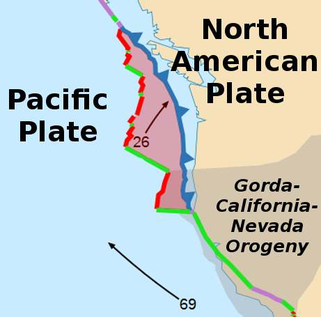
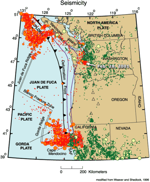
The Juan de Fuca Plate, named after the explorer of the same name, is a tectonic plate, generated from the Juan de Fuca Ridge, and subducting under the northerly portion of the western side of the North American Plate at the Cascadia subduction zone. It is bounded on the south by the Blanco Fracture Zone (running northeast off the coast of Oregon, USA), on the north by the Nootka Fault (running southwest off Nootka Island, near Vancouver Island, British Columbia, Canada), and along the west by the Pacific Plate (which covers most of the Pacific Ocean and is the largest of Earth's tectonic plates).
The smallest of Earth's tectonic plates, the Juan de Fuca Plate is a remnant part of the once vast Farallon Plate, which is now largely subducted under the North American Plate. The Juan de Fuca plate itself has since fractured into three pieces, and the name is applied to the entire plate in some references, but in others only to the central portion. When the three fragments are so distinguished, the piece to the south is known as the Gorda Plate and the piece to the north is known as the Explorer Plate. The separate pieces are demarcated by the large offsets of the undersea spreading zone.
This subducting plate system has formed the Cascade Range, the
Cascade Volcanic Arc, and the Pacific Ranges, along the west coast of
North America from southern British Columbia to northern California.
These in turn are part of the Pacific Ring of Fire, a much larger -
scale volcanic feature that extends around much of the rim of the
Pacific Ocean.
The last megathrust earthquake at the Cascadia subduction zone was the 1700 Cascadia earthquake, estimated to have a moment magnitude of 8.7 to 9.2. Based on carbon dating of local tsunami deposits, it occurred around 1700. As reported in National Geographic on 8 December 2003, Japanese records indicate the quake caused a tsunami in Japan which occurred during the evening of Tuesday, 26 January 1700.
In 2008, small earthquakes
were observed within the plate. The unusual quakes were described as
"more than 600 quakes over the past 10 days in a basin 150 miles
southwest of Newport".
The quakes were unlike most quakes in that they did not follow the
pattern of a large quake, followed by smaller aftershocks; rather, they
were simply a continual deluge of small quakes. Furthermore, they did
not occur on the tectonic plate boundary, but rather in the middle of
the plate. The subterranean quakes were heard on hydrophones, and
scientists described the sounds as similar to thunder, and unlike
anything heard previously.
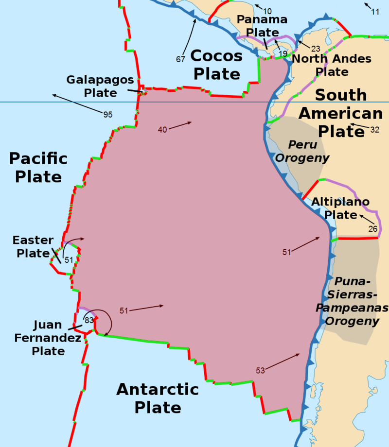
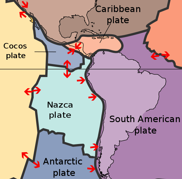
The Nazca Plate, named after the Nazca region of southern Peru, is an oceanic tectonic plate in the eastern Pacific Ocean basin off the west coast of South America. The ongoing subduction along the Peru - Chile Trench of the Nazca Plate under the South American Plate is largely responsible for the Andean orogeny. The Nazca Plate is bound to the west to the Pacific Plate and to the south with the Antarctic Plate through the East Pacific Rise and the Chile Rise respectively. The movement of the Nazca Plate over several hotspots has created some volcanic islands as well as east - west running seamount chains that subduct under South America. Nazca is a relatively young plate both in terms of age of rocks and existence as independent plate.
A triple junction, the Chile Triple Junction, occurs on the seafloor of the Pacific Ocean off Taitao and Tres Montes Peninsula at the southern coast of Chile. Here three tectonic plates meet: the Nazca Plate, the South American Plate, and the Antarctic Plate.
The eastern margin is a convergent boundary subduction zone under the South American Plate and the Andes Mountains, forming the Peru - Chile Trench. The southern side is a divergent boundary with the Antarctic Plate, the Chile Rise, where seafloor spreading permits magma to rise. The western side is a divergent boundary with the Pacific Plate, forming the East Pacific Rise. The northern side is a divergent boundary with the Cocos Plate, the Galapagos Rise.
The subduction of the Nazca plate under southern Chile has a history of producing massive earthquakes including the largest ever recorded on earth, the moment magnitude 9.5 1960 Valdivia earthquake.
A second triple junction occurs at the northwest corner of the plate where the Nazca, Cocos, and Pacific Plates all join off the coast of Colombia. Yet another triple junction occurs at the southwest corner at the intersection of the Nazca, Pacific, and Antarctic Plates off the coast of southern Chile. At each of these triple junctions an anomalous microplate exists, the Galapagos Microplate at the northern junction and the Juan Fernandez Microplate at the southern junction. The Easter Island Microplate is a third microplate that is located just north of the Juan Fernandez Microplate and lies just west of Easter Island.
The Carnegie Ridge is a 1350 km long and up to 300 km wide
feature on the ocean floor of the northern Nazca Plate that includes the
Galápagos archipelago at its western end. It is being subducted under
South America with the rest of the Nazca Plate.
Darwin Gap is the area between the Nazca
Plate and the coast of Chile, where Charles Darwin experienced the
earthquake of 1835. It is expected that this area will be the epicenter
of a major quake in the near future.
The absolute motion of the Nazca Plate has been calibrated at 3.7 cm/yr east motion (88°), some of the fastest absolute motion of any tectonic plate. The subducting Nazca Plate, which exhibits unusual flat - slab subduction, is tearing as well as deforming as it is subducted (Barzangi and Isacks). The subduction has formed, and continues to form, the volcanic Andes Mountain Range. Deformation of the Nazca Plate even affects the geography of Bolivia, far to the east (Tinker et al.). It was on the Nazca Plate that the 1994 Bolivia earthquake occurred, measuring a magnitude MW of 8.2 and the strongest earthquake occurring deeper than 300 km.
Luckily, very few islands are there to suffer the earthquakes that are a result of complicated movements at these junctions. Juan Fernández Islands is an exception.
The precursor of the Nazca Plate and the Cocos Plate to its north was the Farallon Plate, which split in late Oligocene times, about 22.8 Mya, a date arrived at by interpreting magnetic anomalies.