<Back to Index>
- Cartographer Abraham Ortelius, 1527
- Architect Peter Behrens, 1868
- 3rd Prime Minister of Imperial Russia Pyotr Arkadyevich Stolypin, 1862
PAGE SPONSOR
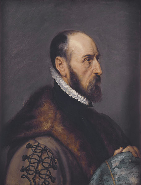
Abraham Ortelius (Abraham Ortels) (April 14, 1527 – June 28, 1598) was a Flemish cartographer and geographer, generally recognised as the creator of the first modern atlas, the Theatrum Orbis Terrarum (Theatre of the World). He is also believed to be the first person to imagine that the continents were joined together before drifting to their present positions.
Ortelius was born in the city of Antwerp, which was then in the Habsburg ruled Seventeen Provinces and is now in Belgium. A member of the influential Ortelius family of Augsburg, he traveled extensively in Europe. He is specifically known to have traveled throughout the Seventeen Provinces; in southern, western, northern, and eastern Germany (e.g., 1560, 1575 – 1576); France (1559 – 1560); England and Ireland (1576), and Italy (1578, and perhaps twice or thrice between 1550 and 1558).
Beginning as a map engraver, in 1547 he entered the Antwerp guild of St Luke as afsetter van Karten. His early career was that of a businessman, and most of his journeys before 1560 were for commercial purposes (such as his yearly visits to the Frankfurt book and print fair). In 1560, however, when travelling with Mercator to Trier, Lorraine, and Poitiers, he seems to have been attracted, largely by Mercator’s influence, towards the career of a scientific geographer; in particular he now devoted himself, at his friend’s suggestion, to the compilation of that atlas, or Theatrum Orbis Terrarum (Theatre of the World), by which he became famous.
In 1575 he was appointed geographer to the king of Spain, Philip II, on the recommendation of Arias Montanus, who vouched for his orthodoxy (his family, as early as 1535, had fallen under suspicion of Protestantism). In 1578 he laid the basis of a critical treatment of ancient geography by his Synonymia geographica (issued by the Plantin press at Antwerp and republished in expanded form as Thesaurus geographicus in 1587 and again expanded in 1596. In this last edition, Ortelius considers the possibility of continental drift, a hypothesis proved correct only centuries later).
In 1596 he received a presentation from Antwerp city, similar to that afterwards bestowed on Rubens. His death on June 28, 1598, and burial, in St Michael’s Præmonstratensian Abbey church in Antwerp, were marked by public mourning. Quietis cultor sine lite, uxore, prole, reads the inscription on his tombstone.
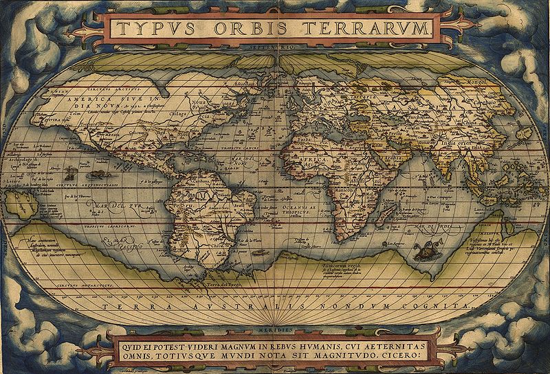
In 1564 he completed a "mappemonde", eight - leaved map of the world, which afterwards appeared in reduced form in the Theatrum. The only extant copy of this great map is in the library of the University of Basel (cf. Bernoulli, Ein Karteninkunabelnband, Basle, 1905). He also published a two - sheet map of Egypt in 1565, a plan of the Brittenburg castle on the coast of the Netherlands in 1568, an eight - sheet map of Asia in 1567, and a six - sheet map of Spain before the appearance of his atlas. On May 20, 1570, Gilles Coppens de Diest at Antwerp issued Ortelius’ Theatrum Orbis Terrarum, the "first modern atlas" (of 53 maps). Three Latin editions of this (besides a Dutch, a French and a German edition)
appeared before the end of 1572; twenty - five editions came out before
Ortelius' death in 1598; and several others were published
subsequently, for the atlas continued to be in demand until about 1612.
Most of the maps were admittedly reproductions (a list of 87 authors is
given in the first Theatrum by
Ortelius himself, growing to 183 names in the 1601 Latin edition), and
many discrepancies of delineation or nomenclature occur. Errors, of
course, abound, both in general conceptions and in detail; thus South America is initially very faulty in outline, but corrected in the 1587 French edition, and in Scotland the Grampians lie between the Forth and the Clyde;
but, taken as a whole, this atlas with its accompanying text was a
monument of rare erudition and industry. Its immediate precursor and
prototype was a collection of thirty - eight maps of European lands, and
of Asia, Africa, Tartary and Egypt, gathered together by the wealth and enterprise, and through the agents, of Ortelius’ friend and patron, Gilles Hooftman, lord of Cleydael and Aertselaer: most of these were printed in Rome, eight or nine only in the Southern Netherlands. In 1573 Ortelius published seventeen supplementary maps under the title Additamentum Theatri Orbis Terrarum.
Four more Additamenta were to follow, the last one appearing in 1597.
He also had a keen interest and formed a fine collection of coins, medals and antiques, and this resulted in the book (also in 1573, published by Philippe Galle of Antwerp) Deorum dearumque capita ... ex Museo Ortelii (reprinted in 1582, 1602, 1612, 1680, 1683 and finally in 1699 by Gronovius, Thesaurus Graecarum Antiquitatum. vol. vii). The Theatrum Orbis Terrarum inspired a six volume work entitled Civitates orbis terrarum edited by Georg Braun and illustrated by Frans Hogenberg with the assistance of Ortelius himself.
In 1579 he brought out his Nomenclator Ptolemaicus and started his Parergon (a series of maps illustrating ancient history, sacred and secular). He also published Itinerarium per nonnuilas Galliae Belgicae partes (at
the Plantin press in 1584, and reprinted in 1630, 1661 in Hegenitius,
Itin. Frisio - Hoil., in 1667 by Verbiest, and finally in 1757 in
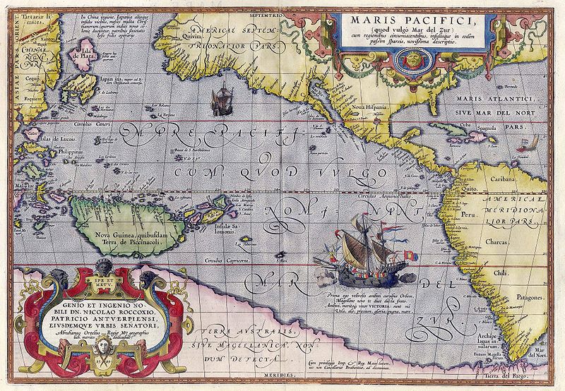
Leuven), a record of a journey in Belgium and the Rhineland made in 1575. In 1589 he published Maris Pacifici, the first dedicated map of the Pacific to be printed. Among his last works were an edition of Caesar (C. I. Caesaris omnia quae extant, Leiden, Raphelingen, 1593), and the Aurei saeculi imago, sive Germanorum veterum vita, mores, ritus et religio. (Philippe Galle, Antwerp, 1596). He also aided Welser in his edition of the Peutinger Table in 1598.
Originals
of Ortelius' maps are popular collector's items and often sell for tens
of thousands of dollars. Facsimiles of his maps are also available from
many retailers. A map he made of North and South America is also
included in the world's largest commercially available jigsaw puzzle which is of four world maps. This puzzle is made by Ravensburger, measures 6 feet (1.8 m) × 9 feet (2.7 m), and has over 18,000 pieces. Ortelius
was the first to underline the geometrical coincidence between the
coasts of America and Europe - Africa, and to propose continental drift as an explanation. Kious described Ortelius' thoughts in this way: The continental drift theory was generally accepted in geosciences only during the second half of the 20th century, after the works by Alfred Wegener.
![]()